The trip mentally started several years ago, as Alaska was the only state I hadn't been in yet. Also, I'd flown over the lower 48 already, and I'd just as soon not be a rich gringo in Mexico, where law enforcement officials need to wear uniforms because you can't tell the difference between them and the banditos otherwise. And flying over the North Atlantic seemed to be a bit much financially and besides I'd then have to take a course in shark evasive maneuvers.
So you see, Alaska was the next natural destination. I was originally going to go last summer, but the data never achieved critical mass, but it's just as well. Ketchikan averages 13 feet (yes, feet, not inches) of rain (not snow) per year. Last year it started raining in April/May and didn't stop until August. The weather knew I had been considering the trip last year.
It was interesting that although Alaska always seemed formidable indeed, the size seemed to me to wax and wane. I'm one of those types that has no sense of how apparently large a distance is merely by knowing a numeric quantity, for instance, the number of honest time sharing salesmen stacked end to end to demonstrate the size of an atom. I have to express distances in the form of something I know about, like how many "Boston_to_New_Yorks" it is. Then I really know how far something is.
Also, I'd heard that Alaska has a hostile climate and mosquito clouds as dense as hippies at Woodstock. As time got closer and I really got down to the task of how far things were, Alaska seemed somehow much more manageable. I think the main reason Alaska turned out to be non-formidable in real life was that the weather cooperated rather well.
On the personal side, the trip regularly had "interpersonal dynamic" issues to resolve, but not unexpectedly when you consider that an airplane on a long trip is really a Skinner box with wings. But I feel that it was more than made up in the overall grandeur of the adventure.
The major emotional trauma involved with the trip planning was the purchasing of bullets for the required gun. I hadn't even touched a gun in more than 25 years and had as much interest in guns as I had in Jim Bakker's air conditioned dog house. I actually had to go to a gun store, look like I knew something, and ask to purchase *bullets*.
I borrowed the gun (a British Enfield .303 World War II rifle) from Kim who took me to the gun range so I could find out which end to point at the bear. We fired a .22 rifle first, then the 303. After about 10 shots, my shoulder was sore from the 303 kick because the shells are so powerful. An official from the Russian embassy actually came over to find out if we were violating the nuclear test ban treaty. Then I went back to firing the .22 and I couldn't even tell if it'd gone off it was so much tamer than the 303.
One of the major goals was to stop by Prince William Sound and register our disgust at Exxon (are the others any different?) by personally frowning at the oil slick and see how the paper towels were holding out. I figured that it was only patriotic to follow in the footsteps of our illustrious VP, who is also chairman of the "Society to Promote Idiocy as a Form of Intellect".
Secondary goals were to leave on the June 24th for a family reunion in Racine, WI, get as far as Barrow, Alaska, and make it back home sometime before July 23rd, while spending less money than Tammy Bakker spends on makeup per month.
The trip was a lot safer because there were two planes: my Mooney with Sue and Meg (my 13yr old daughter) aboard, and Steve Briggs's Apache with 5 aboard (including several kids). His Apache has lots of speed modifications and larger engines, so he is a few knots faster than I am at cruise. When we flew together (most of the time), we didn't file flight plans except in Canada where it was required, figuring that flying together would be safer than flight plans anyway.
Steve can maintain about 4000 to 5000 feet density altitude if he loses an engine, fine for around here, but not too useful in mountains where 5000 feet is well below ground level. On the other hand, I can't maintain even one foot if I lose one engine. Flying over icy water wasn't too inviting. I've heard that Mooneys float for about 1 minute before sinking. At least with Steve around, they'd know where to send the divers.
I did essentially all of the Mooney flying of the trip, with Sue and Meg doing their best to fill the time with as much imagination as convicts with several years until parole. They slept, did beadwork, read, wrote, etc.
I left with $1000 Amex travelers checks and $700 cash, and wound up home with all the travelers checks, $150 cash, and a fistful of Visa stubs to the tune of about $1500. I never had to use the Exxon card; if they wouldn't take Visa, they wouldn't take Exxon. I could understand their attitude after the spill, I'd just as soon not take Exxon either.
The packing process was basically to throw away all boxes and repackage everything into plastic zip-lock bags to save space and weight. Our whole life appeared to consist of carefully packaged scientific specimens, each one carefully marked and inventoried for later lab analysis.
There are numerous required items to be carried for survival in Canada and Alaska, the current list of which is available from AOPA. Most of the things on the list you just buy or borrow and you have them. Food, however, was another issue. Canada requires 10,000 calories per person on board, whereas Alaska requires 2 weeks of food on board per person. Sue fortunately picked up the ball on that issue. She found that most people say you need more than 1000 calories per day for sedentary work, but if surviving, we figured we could get by on a lot less, and since the Alaska regulation was pretty subjective, we'd just go for the Canada regulation. We had heard stories that some people would take dry dog food - the terrible taste would make it last longer.
Here's our list of survival food. We had additional food for camping, etc., but the following was what we figured in for the regulations:
| Food | Quan | Calories for each item | Total item calories |
|---|---|---|---|
| Macaroni & cheese (with powdered milk) | 6 boxes | 700 | 4200 |
| Shaklee Drink Mix | 45 bags | 210 | 9450 |
| Quinoa Grain | 4 boxes | 1290 | 5160 |
| Shaklee Energy Bars | 23 | 200 | 4600 |
| Fruit Rolls | 8 boxes | 50 | 400 |
| Dates | 40 | 20 | 800 |
| Elbow Macaroni | 40 oz | 105 | 4200 |
| Raisins | 3 cups | 500 | 1500 |
| Total Overall Calories | 30310 |
For the elusive snare wire, I brought along aircraft stainless steel safety wire, figuring it could do double duty in case we needed to work on the plane.
For mosquitoes we bought a whole pile of Avon "Skin-so-soft" skin lotion and mosquito head nets. Fortunately for us we never had to use it because after we got back, we found that it's the "Skin-so-soft" bath oil that works as a repellant, not the skin lotion.
We were never inspected to make sure we had all the required stuff aboard. The closest we came to having our survival stuff being verified, was in Canada, because when you file a flight plan, they ask you if you have survival stuff on board and you say just yes or no. I wondered what they would do if you answer no, but I didn't want to get them suspicious so I didn't ask. Anyway, the Canadian customs person said that Canadian customs aren't interested if you have the required stuff aboard.
I don't know if anybody inspects for survival stuff anywhere except maybe in Ketchikan since so many people from the lower 48 pass through there. But since we didn't stop in Canada on the way to Ketchikan, we didn't have to go thru customs in Ketchikan, so nobody bothered us about it.
I did talk to the US Customs agent in Montana on the way back and he said that a couple of years ago he saw people coming back from a Cessna fly-in in Fairbanks without even a blanket aboard. I guess they're a member of the "survival_stuff_merely_prolongs_the_agony" school of thought, or else maybe they just followed roads.
We brought tiedown ropes but no anchors. Most places we stopped had anchors and ropes, and some had only anchors so we used our ropes, and some had nothing at all. On the rare occasions for which we might have used the anchors, the ground was too hard to screw anything in anyway.
I figured with everything aboard (I even left behind the towbar), I was about 50 lbs under gross weight with full tanks and 3 people. All the baggage weighed about 200-220 lbs, weighed on a digital (not Digital) scale. I didn't trust the scale at the low end of the weight spectrum, figuring that it'd be more accurate closer to a person weight than if I just weighed a bunch of bags alone. I first weighed myself, then repeatedly weighed myself with an armload of bags, looking like Santa with an armload of presents, and subtracting my weight out each time.
The total time on the plane was 75 hours, with about 8.7 hours actual in the clouds instrument time, and all the actual was in the lower 48. The most expensive gas we bought in the US (Alaska) was $2.50/gal, but Bettles was $3.00/gal (we didn't stop there). Bettles is that expensive because they fly gas in. All US gas was 100LL (tinted blue).
Canadian gas was all pretty much CDN$.75 or .80/liter. After factoring in the Canadian dollar vs the US dollar, imperial gallons vs US gallons, and debentures vs furlongs, the gas came to about US$2.40 (assuming about 18% Canadian/US exchange rate). All Canadian gas (Yukon and Alberta) was green 100/130, but everybody said they were scheduled to go to 100LL by the end of the year.
Summary of our itinerary (I didn't fly at night at all):
| Date | Flight Time | Actual IFR | Destination |
|---|---|---|---|
| 6/24/89 | from 6B6, Minuteman, Stow, MA | ||
| 6/24/89 | 2.7 | .5 | to IAG Niagra Falls, NY |
| 6/24/89 | 3.4 | 1.0 | to RAC Racine, WI |
| 6/27/89 | .7 | 0 | local flight |
| 6/29/89 | 3.8 | 0 | to HON Huron, SD |
| 6/29/89 | 1.9 | 0 | to RAP Rapid City, SD |
| 6/29/89 | 2.5 | 0 | to BIL Billings, MT |
| 7/1/89 | 3.1 | 0 | to SFF Spokane, WA |
| 7/1/89 | 2.2 | 1.0 | to REN Renton, WA |
| 7/1/89 | .3 | 0 | to S50 Auburn, WA |
| 7/5/89 | .3 | 0 | to BFI Boeing Field, WA |
| 7/5/89 | .8 | 0 | to ORS Orcas Island, WA |
| 7/5/89 | .9 | 0 | to S50 Auburn, WA |
| 7/6/89 | .8 | 0 | to BLI Bellingham, WA |
| 7/6/89 | 4.3 | 0 | to KTN Ketchikan, AK |
| 7/7/89 | 3.5 | 0 | to YAK Yakutat, AK |
| 7/7/89 | 3.2 | 0 | to MRI Merrill (Anchorage), AK |
| 7/9/89 | 2.0 | 0 | to FAI Fairbanks, AK |
| 7/9/89 | 3.8 | 0 | to BRW Barrow, AK |
| 7/10/89 | 4.1 | 0 | to FAI Fairbanks, AK |
| 7/13/89 | 2.1 | 0 | to YDA Dawson City, YUK |
| 7/13/89 | 2.4 | 0 | to YXY Whitehorse, YUK |
| 7/14/89 | 3.2 | 0 | to YYE Fort Nelson, BC |
| 7/14/89 | 2.9 | 0 | to YZH Slave Lake, AL |
| 7/15/89 | 1.3 | 0 | to YXD Edmonton, AL |
| 7/15/89 | 1.5 | 0 | to EG4 Drumheller, AL |
| 7/17/89 | 1.8 | 0 | to HVR Havre de Grace, MT |
| 7/17/89 | 3.1 | .4 | to BIS Bismark, ND |
| 7/18/89 | 2.7 | 0 | to BRD Brainard, MN |
| 7/18/89 | 3.7 | 1.6 | to RAC Racine, WI |
| 7/19/89 | 4.6 | 3.1 | to 4B2 Riverside, Utica, NY |
| 7/20/89 | 1.7 | 1.1 | to 6B6 Minuteman, Stow, MA |
| Totals | 75.0 | 8.7 |
True to form, Stow and the whole Mass area was socked in by low fog, so we were delayed getting out by 1/2 hour or so while the air traffic control evacuated the airspace around Minuteman airport. On top was clear and smooth, 2.7 hours to Niagra Falls but only .5 hours of actual in the clouds time. I stopped at Niagra falls because the gas was advertised to be $1.78 in the AOPA fuel watch, a bargain these days, but it turned out to be $2.03/gal, about average for the trip. So much for the fuel watch. I bet they lower their prices for the 5 minutes it takes to tell AOPA what the fuel price is.
The oil temp went off-scale in a flaky manner again (sigh). So much for getting the gauge repaired at the shop 3 times so far. It reminds me of the poster with the caption "Trained professionals working on your problem" and it shows the 3 stooges hammering away on a watch. I'll have to look at the gauge myself in Racine when I get there. Fortunately, it's one of the least useful gauges in the plane because if the oil temp is too high, the oil pressure will be too low. It's definitely the gauge because all of a sudden it goes off scale like a loose connection.
On to Racine, WI, over Canada. Canada was so hazy, I could see only straight down and a fuzzy sun at 6000 feet, and no horizon. I counted 1 hr of actual because I had no visual reference, even though technically it was probably VFR. Over Michigan, there were real clouds with vertical development and bumps, rather than just wimpy haze.
Over Lake Michigan (about 70 mi over water), the clouds stopped abruptly at the shoreline so the lake was clear until I got near the Wisconsin shoreline where there was a very low layer over the water. Fortunately, the land was completely clear, because the layer would have been too low for me to do an instrument approach into the airport. The airport is only a couple of miles from the shoreline.
Over the lake, I always talk to the approach controllers. If I have a problem, they'll know about it immediately by the frantic pitch of my voice.
I've got 4 cousins in Racine, so I called Tom, the one most likely to have the tools I need to take out the gauge. He arrived, and we removed the gauge to be looked at later at his house.
My cousins had rented a hall for an evening, so we ate, talked, laughed, set off fireworks, and looked out for the police (because they're illegal there). I was pretty tired from being up late packing the previous night, then up early to fly for 6 hours, with one time zone change.
I rode with Andy to the wharf area. It was incredibly built up in the past few years with a modern marina. The people from Chicago with money now park their boats up here in Racine, only an hour or so from Chicago. It's just American disposable income and overextended credit at work. In the evening, the beach scene was something out of the American Graffiti movie - anybody who was anybody was parked at the beach drinking beer.
This nobody was glad to climb into the closest thing to a bed I'd see for quite some time - a couch and sleeping bag. Marc and Mary had 16 people sleeping in their house which was no small feat considering they have 2 bathrooms, one working bathtub, and no shower. That gives a bathroom bandwidth of 1.5 to 16, but a rather poor shower bandwidth of 0 to 16.
Later, we had a industrial-size pot of ham and eggs for breakfast, and shot off a few bottle rockets and tanks. Then off to a park in Racine for an all day picnic where we succeeded in losing the Aerobie and breaking a boomerang, but no other casualties. I also borrowed Andy's motorcycle to get a round a bit easier. That's the motorcycle that up to now, every time I've visited Racine and borrowed it, something's happened and I've had to call Andy up to get rescued. It seemed to run fine for now.
We moved to Tom and Chris's for a couple of days because their guests left and they have a non-zero shower bandwidth. On the other hand, my camera batteries quit, the bathroom scale I was going to use to weigh the plane contents had dead batteries, and Tom's VOM meter I was using to measure the batteries had dead batteries so I bought lots of batteries. I felt like a walking ad for Dura-cell.
Feeling myself in a fixing frenzy, I began demolition work on the Mooney instrument cluster and found a completely fried wire inside. I replaced the wire and recalibrated with the values given to me by the shop, and things started to look much better. I installed it back in the plane, and the same fuel gauge is still dead. Back on bench it works. I hate problems like that.
I discovered that the gauge would work at 13.5V on bench, but not at 12.5V in the plane without the generator running. I decided that because the gauge works OK with the generator running, it'd at least get me thru the trip, but I brought the calibration pots with me just in case. I'll send it back for the 4th time when I get home. I also noticed that whoever had working on it previously must have been working on it while they were drunk or being tickled, because many of the solder joints were done very poorly. Many wires had burn marks all over the insulation. So much for trained and qualified professionals. I should have just given it to a marine drill sergeant and he could have yelled at it.
A violent storm blew thru this afternoon about 3pm, reminding me of the time one came thru a few years ago. Everybody huddled in the basement due to the tornado watch warnings, except that Marc was running around outside, placing microphones on the porch to try to record the impressive thunder!
My cousin Marc has the hobby of blacksmithing, which means he can take his frustrations out by pounding on metal, make lots of noise, and not look ridiculous. He's actually made some pretty nice things. He has the vanity license plate of "LBS FE". For those of you whose names start in the latter half of the alphabet and spent science class asleep in the back of the classroom, that translates to "pounds iron". He asked Meg what she wanted, and she said "shark". Of course, if you ask her who is the televangelist under indictment for tax fraud, she'd also say "shark", but then, that would be correct. Marc ended up changing a 1/2 inch square steel rod into a very respectable shark. I was impressed.
Blacksmithing is quite interesting. Hot metal becomes rather malleable, like politician's principles, when it's cherry red. You can work it without it breaking. The blast furnace is quite simple - just a cast iron depression in a table, with the bottom of the depression containing holes hooked to an electric blower. You get the coal and coke going, and the blower heats the metal to a cherry color. It can get so hot, that carbonized metal can burn off carbon in spontaneous showers of sparks. I was also amazed that metal isn't that good a conductor of heat as you can hold a solid metal bar about 2 feet away from the cherry end and the rod isn't very warm. Marc also doesn't believe in using gloves, because you get burned too much
from embers that might go down the cuff of the glove as well as wearing gloves makes you more careless than if you use your bare hands.
The weather was gorgeous, without a cloud in the sky. At 4500 feet, the flight was bump-less too. Who needs autopilot? The approach controller is friendly. I think the friendliness of controllers is directly proportional to the distance from the northeast corridor.
We crossed the mighty Mississippi, a wide brown ribbon from up here, and continued on over Iowa. It's all big farms out here, and mostly dirt roads laid out on a grid. Each square of road has a farmhouse or two, and each farmhouse had it's own clump of trees on the northwest side of the house probably to protect the house from storms. There were no other trees except around houses.
The fields contain streaks of light colored soil from God's airbrush indicating the dryer sections. There's also an interesting contrast between the long straight roads and the dribbley, meandering streams. Back in the northeast it's more difficult to tell the difference because the roads back home are all windey and dribbley too. Back home, the main difference is that the roads contain brightly colored dots always bumping into each other like brownian motion.
We noticed our ground speed had dropped to 120 knots (140 knots airspeed so there was a substantial headwind) so we descended to 3000 feet. At a lower altitude, the wind is generally weaker, but we
didn't gain much. Down to 2700 feet. There was an amazing amount more turbulence at the lower altitude. A silly 300 feet made quite a difference. Also, at 2700 feet we had to be more on the lookout for radio towers. Remember that the ground is 1300 or 1400 feet altitude out here.
We landed at Huron, SD, with a FSS on the field, and found out we hadn't even crossed the possibly threatening front yet. The restaurant here was pretty expensive even if the food is gold plated, so we push on to Rapid City for lunch. We're told it's a brand new terminal and really nice. Rapid City is also past the front. I'm feeling a bit tired from getting up early and doing lots of flying, so a short hop will be nice.
We passed over Lake Sharpe, just southeast of Pierre SD, and it's still good weather. The lake has interesting badlands along the shoreline - like fingers of water grasping and sinking into the muddy shore.
On toward the badlands, I lost Steve (who was flying down low) and my Loran at the same time, so we just flew our own way into Rapid City. Steve got lined up at the military base just north of the city (contrary to his Loran info) and was jarred back to reality by an up close and personal view of a B-1 bomber. The military airport stands out so much better than even a large civilian field that it's an easy mistake to make.
After landing, we noticed large nasty cloud buildups in the direction of the Rushmore monument. Should we eat lunch and risk not seeing the monument? True power rests in the proletariot, or the passengers in this case, so there we ate in spite of the price at this brand new restaurant and the slow service. If that wasn't enough, a huge group at the next table began singing some song before eating, so we figured it'd be a nice neighborly thing to do to sing "Yellow Submarine" when we get ours. Fortunately for them, good taste caused amnesia when the time came.
We departed, with the weather holding up, but the monument was in the shade. Also, ATC wanted us at 7700 feet and a mile away so you almost need binoculars to see the stupid thing. It's not worth a picture, and it's certainly not like the last time I came thru and the rules were the standard ones so I could get close enough to get a picture. The feds ruin everything for transients, by making stupid rules for situations that happen rarely, and certainly not often or long enough to annoy folks. It's just like the Grand Canyon, they've made equally stupid rules against transient pilots to placate the tourists who want quiet, when the real problem are the same tourists taking scenic flights in noisy airplanes. The Canyon was incredibly busy with commercial traffic, but no other transients around.
Onward to Devil's tower in southeast Wyoming. That was the prominent physical feature in the movie "Close Encounters of the Third Kind", featuring Richard Dreyfus making a likeness out of mashed potatoes. At least there aren't any special restrictions around here. There are a few showers to our east, but it's a gorgeous clear sky to our west. We must finally be past the front. We circled around the tower several times trying to get each other's picture against the tower. This precise formation stuff is much harder than I thought. When we got the pictures back later, we discovered we were way too far away from each other.
Onward over Little Big Horn and to Billings, MT. for a stop. There's nothing to see from the air of Custer's monument, especially when we're not really sure what we're looking for. Billings, MT is on a mesa overlooking the city. I found a courtesy car for free that they'll let us have for a couple of days! It's an old VW microbus from the days when the bison were plentiful on the plain. The microbus had plenty of room for everybody, which was handy, because we had to regularly fan out and search for first gear because the shifter was so loose. The windshield was cracked (seems that there must be a regulation that all cars out here must have cracked windshields), and the brakes were questionable too, but the price was right. Also, the airport folks had installed a clever device so that if you got too far away from the airport, the horn would randomly honk just often enough to be irritating.
We drove around town, and stopped at the Sheraton for the night - not my normal low budget trip, but Steve picked the accommodations. I supose it'll be interesting to see how the other half vacations. We ate at a rib place with sauce so hot that they could probably do nuclear fusion experiments with it. I was really dragging from flying, lack of eating, and low sleep. My nose started running as if from hey fever, but this is supposed to be the west with dry atmosphere and no pollen.
There was a fenced field where Custer's last stand was and a marker for each soldier that fell, and one marking where Custer "fell". Doesn't "fell" sound much better than "got killed"? Reality got him even without the benefit of modern management techniques. He evidently had several hundred cavalry to 3000 or so Indians.
I wonder how could they figure out where each person precisely was before the invention of the instant replay and the genetic mutation called Howard Cosell. It was amazing to consider that he tried to control a battle with no communication between battalions or gaggles or whatever you call globs of soldiers. It looked like it was disorganized, more like a basketball free-for-all. The country around here is gorgeous. The weather really got hot today, up to 105 degrees according to the radio, but it's dry so I didn't really feel it to badly. We did eat ice all the way back home - or what we called home for that night. We hurried to the sanctuary of the air conditioned room.
The white man actually had the last word though, when shortly after the FAA heard about the massacre, they assigned the abbreviation "SUX" for the three letter abbreviation for the Sioux City, Iowa airport. The natives of the city are still trying to change the abbreviation to this day.
There was an interesting museum on the road on the way back - school house, train station, church with a bell you can ring, and a tepee. The train station was not out of use all that long because there was a rack of repeaters of some sort with solid state stuff inside.
I still feel really drained, but much better than last night. My nose is running less even though I was around goldenrod. We relaxed back home, and then decided to go to some Indian caves a bit out of town. They were quite fascinating, with red drawings. It's interesting that if you make drawings on rocks now, it's called graffiti and they arrest you. If you made drawings on rocks 100 years ago that look like scribblings made by a child with poor muscle control, they're called petroglyphs and they protect them. Graffiti artists are permanently ahead of their time.
The monument consisted of shallow caves. We met the ranger who was just closing up because it was about 7:30pm by this time (8pm closing). On the way out, we almost ran over two snakes, one unknown type about 3 feet long, and one rattlesnake about 2 feet long lying in the road. We decided to regard the snakes like lightening and stay in the van for protection and just took some pictures. We drove away as the ranger pulled up behind us. He got out of the truck and took a shovel and began whacking at it. The snake appeared to jump about 3 feet in the air. I always thought rattlesnakes were endangered species and protected, but I guess not if a park ranger whacks at them with a shovel. On the other hand, he lived in a trailer near the caves (discreetly out of sight) and I suppose I wouldn't want rattlesnakes hanging around my front yard either. It sure gave real meaning to the signs that said "Stay on the path".
We drove back to Billings and found a Japanese restaurant like Beni Ha Ha's that prepares food at the table, but we wanted to have enough money left over to finish the trip. Then off to a Mexican restaurant, but it closed about 10 minutes before we arrived. Next, we went to a Denny's type of place that was crowded but good. The salad bar light was out so it was a bit tricky getting past the poisonous vegetables like zucchini and cauliflower. I must have avoided that stuff because I'm here to tell about it.
In Billings this weekend, there must have been a regional hot rod competition or something. There were all sorts of stripped down, suped-up, chopped down, and channeled up hot rods, with incredible paint jobs. I saw a '33 Ford, painted a firey orange, that was supercharged and had two Holley 4-barrel carbs. I'll bet Henry is rolling in his grave. Elsewhere, there was an interesting purple dragster. The back wheels were so big that they were a hazard for lowflying planes. And extending from the back of the car was a frame that looked like the car had been rear-ended by a shopping cart. The frame and little wheels must have been there to prevent the car from going over backwards during a wheelie. And then, of course, there was the parachute mounted on the back, probably for dropping it from a C-130 behind enemy lines.
We decided to go to Seattle tomorrow in two hops, and skip Yellowstone because in spots the ground is 8000 feet, and our performance on a warm day is pretty poor (not to mention the plane's performance), because we're close to gross weight.
"More power, Scotty!"So we decide to scream on in to Seattle and see Mt St Helen on a day trip if we decide to. I lined up Tom and Beth Miller to be the welcome recipient of Hannibal's traveling hordes.
"That's all she'll take, Capt'n!"
We stopped at the grocery store which must have been the only one in town considering how long we looked for one. I waited outside in the VW next to this pickup truck. A guy hopped in the back and was breaking apart sixpacks of sodas into a cooler. The truck started rolling back slowly. We figured he couldn't have missed it rolling so we didn't say anything, but sure enough, about 50 feet away it stopped, then the guy finished, looked up, and had this priceless quizzical expression on his face! Of course, I was falling out of the VW laughing so hard.
We returned the VW, departed from Billings, and crossed the Rockies with quite good visibility, but we couldn't have gone much higher than 8000 feet or so due to clouds. There were an incredible number of lumber roads all thru the woods in Idaho as well as interesting lakes up in the mountains, with snow on the higher mountains. From our pserspective, the lakes were like little puddles or goldfish ponds.
On into Spokane WA, Felds Field, where 15W50 oil was an outrageous $4/quart. A quick peanut butter lunch, and we departed for Renton, WA, near Seattle. The weather was scheduled to be poor over the mountain range just before Seattle, so we filed IFR to be picked up just before we got to the mountain range.
Renton is very near, or actually too near the Seattle TCA (heavily controlled airspace where they yank your license until airplanes are obsolete if you blunder into it). Fortunately we were IFR, so we didn't have to worry about where the TCA was. On Steve's way in, he heard some guy report a parachutist falling out of a cloud near him. They have interesting traffic out here in the west.
The approach to Renton, WA was over the water with a big wall at the far end. Low approaches would allow you to test out how well your airplane floats in water. Also too-fast approaches allow you to test out how well your prop will burrow through solid concrete. On the ground, I called Tom. He was at the Auburn airport working on his plane (what else do pilots do on weekends). Tiedown at Renton was $6/night and rental cars were unavailable, so we decide to push on down the airway to Auburn. It was drizzling (did I hear "liquid sunshine"?) but the visibility was still good.
Both Renton and Auburn are within scowling distance of the Seattle TCA. Actually, the Seattle airport is up on a mini-mesa and the edge of the TCA is only a couple of miles east of the Seattle airport right at the edge of the ridge. So, if you stay low about even with the mesa and follow the highway down about 10 miles, you find Auburn. The VASI lights were the most obvious feature of Auburn, a small enough airport that it's not on the WAC chart at all to save congestion in that area of the map. You realy need a sectional or TCA chart around this area.
The approach to Auburn is quite "interesting" because it has right traffic to runway 15 so that you're squeezed up against the wall of the TCA. We landed, and found transient parking, not far from where Tom was working on the audio of his Comanche - his Dave Clark intercom was acting up. His tail (well, not actually HIS tail, but his Comanche's tail) is painted dark blue with the Alaskan flag stars (the big dipper and the North star) in white.
Tom said he had a friend that had just that day come down from the Alaska panhandle and the weather was gorgeous; exactly contradicting with what flight service was saying the weather was. Hmmm. Conflicting weather data is not good. Flight service is usually pessimistic, but then maybe Alaskan pilots may be overly macho.
The low just west of the Alaska coast has been sitting there for a week and not budging, seemingly bringing low clouds to the panhandle. I sure hope it moves while we're in Seattle. We have several days to wait in Seattle because Steve has work to do at the Seattle site, and it's a long weekend (the 4th of July), so we have to hang around Seattle for several days until Wednesday when work is in session again. It'll be nice to see Seattle because I've heard it's a great place to live, but haven't spent much time there. It'll reduce the chances of an armed insurrection by the passengers. It's a good thing they can't fly by themselves.
Steve rented a car and booked a room at a hotel, and we-all took advantage of Tom and Beth's wonderful hospitality. Tom made a great spaghetti dinner - especially because I was hungry and dehydrated.
Tom and Beth are rebuilding their house, and the rebuild process is still in progress: Remove house from doorbell, throw away house, reinstall new house. Their study was still decorated in early college, much like mine, with wood shelves spaced by cinder blocks. And some shelves were held up by cans of food so if they get too hungry they can always eat their shelves! Because they had no curtains, Beth fashioned these wonderful window coverings out of crepe paper and electrical tape in the form of murals. They were gorgeous! They looked like stained glass. For Christmas, they had a manger setting.
We saw the Klondike Gold Rush Museum National Park in a downtown building. The museum had a big pan of gravel salted with brass nuggets (a typical river bed). The panning process relies on the fact that gold is much heavier than stone, and also on the fact that gold prospectors don't get bored easily. For this exhibit, they used brass, which is about 4 times heavier than gravel, whereas gold is about 10 times heavier than gravel.
The panning process requires much patience; you just slowly wash away the gravel to leave anything that might be heavier in the bottom of the pan. I think he said that a good panner could do a pan in a minute if he was being careful. There can also be gold dust in the bottom so prospectors take mercury and run that around the bottom of the pan because the mercury picks up the gold. Then after awhile, the mercury has the consistency of putty, and they boil off the mercury to leave behind the gold, which explains why gold miners got mercury poisoning a lot. The biggest nugget ever discovered is from Australia and was about 250lbs.
The outfitters way back during the gold rush in Seattle made lots of money because Canadians required prospectors carry in 1 year of provisions (which was about 1 ton) per person. Lots of newspaper articles cleverly linked Seattle with outfitting gold prospectors so that anybody who wanted to try their hand at becoming broke while being very uncomfortable in the woods would come to Seattle. Very few prospectors were actually successful. With the miracle of modern technology, we've got timesharing, swampland in Florida, and lawyers to keep us broke without ever having to leave the comfort of our own home.
At the aquarium we went to the Omnimax Theater - that's one of those extremely wide theaters with wonderful cinematography. They had some great movies of whales, sharks, and scuba divers with some frames containing sharks and scuba divers together. The second movie was about the Mt. St. Helen eruption. That was quite impressive. The movie makers actually got somebody in a 172 (I could just see the wing strut) to fly very close to the eruption. This was while it was still going on! Interesting that the camera didn't show very much turbulence. They appeared to be upwind of the volcano. For the amount they spent on making the movie, I'd think they would have used a better plane.
We saw the fascinating Underground Tour. Seattle, diplomatically named after an Indian chief around there, was originally built on mudflats. After they got toilets in the town, they ran the sewage thru pipes to the ocean, but the tide would back the pipes up so that the lower toilets would operate as very energetic "output" devices rather than the customary "input" devices, if you catch my drift. Anyway, they decided that the city was too low, and in the white man's tradition of fighting nature, they decided to build up the city rather than move elsewhere.
However, they couldn't do the whole town at once, and besides, that would mean that the first floor of a lot of the buildings would then be underground, and that first floor was where all the shops were. So they ended up building retaining walls about where the curbs were and filling the roads, but leaving the sidewalks and shops down low. This meant that people had to use ladders to get from the street level down to the shop level which generated a whole lot of very polite men willing to help ladies up and down the ladders (from the bottom of course). This also meant that because people tied their horses at the street level, as you walked, you had to worry about more things dropping on you than just rain.
The amount of fill ranged from 10 feet down by the shoreline to over 30 feet away from the shore (yes, complete with 30 foot ladders) to give a gradual upslope to meet the cliffs overlooking the city. Eventually, Seattle put roofs over the sidewalks and made shop entrances at the new street level. Some of the underground walks were filled but some are still open today. Thus, Seattle can boast of the first multi-level shopping center in the history of the world because there was a time when both levels were open for business.
Seattle had tremendous problems with potholes in the dirt streets. Initially the town fathers decided that potholes weren't that big a deal, and rather than fill them in, they'd just name them and put them on maps so that people could navigate around them. That's sort of like what we do in the Northeast today. However, along the same lines as the domino theory of communism, the holes got so big they could swallow a whole stagecoach. There was the true story that some kid playing in a boat overturned and drowned, and the hole was so big and muddy, it took quite a long time to locate his body.
The term "skid row" was coined in Seattle, named after the road that had greased logs installed so that logs from up aways could be skidded down to the sawmill. Some inaccurate reporter (they should have stopped his genes when they had a chance) referred to it as "skid row" rather than "skid road".
The town fathers eventually had a census taken and were surprised to discover that they had in Seattle several hundred women who listed their occupation as "seamstress". Now, they thought it was quite unusual to have that many seamstresses, seeing as how the town otherwise consisted almost entirely of burly lumberjacks, so they sent a contingent down to the area in which the seamstresses were living. After considerable in depth research into their profession (supposedly measured in weeks), they found that yes, indeed, the women there were actually working as seamstresses (wink...wink).
The guy I talked to was quite nice and understanding. He said at worst I'd probably just be detained a half an hour or while they did some checking around. Well, that's not too bad. I asked about the rifle too. He said that if I don't register the Enfield rifle here before leaving the states, they must confiscate it on the way back in so I had better register it. I have a Mass gun permit (thus my fingerprints are enshrined in some federal archive), but he said I'd need proof that I didn't buy the gun elsewhere and was importing it. Good thing I asked - Kim would not be happy if I were to "lose" his gun. Well, at least his wife might thank me.
Steve's gun, on the other hand, is a collapsible survival 22 rifle. That one is a "should" register, but my gun is a "must" or they will confiscate it.
Sue drove us in to bum around downtown Seattle. We visited the farmer's market called "Pike St". The farmer's market has great fruit; the cherries were especially good. We shopped, went up the space needle, and rode the monorail. We ate at Denny's much to Meg's disappointment. She kept wanting Japanese. Steve had told her about all this great fish and Japanese restaurants in Seattle.
It looks like the weather is breaking, perhaps at just the right time. The persistent low has run out of federal funding and is being disbanded, so we might have good weather for the panhandle. I looked at the maps again, and the 20,000' mountains haven't moved from where the panhandle hits the main part of Alaska since the last time I looked. I measured the Wash state to Ketchikan distance again hoping if I measure it enough it'll be small enough to make without stopping in Canada, and eliminate all the hassle of Meg not having her birth certificate. As long as we don't stop in Canada, we don't have to talk to customs in Ketchikan. The hop will probably take about 4 1/2 hours.
As it turned out, it wasn't a big deal because we went to an obscure corner of the airport where cargo is handled. I walked into the customs office and was greeted by a matron, who exceeds most building's permissible floor loading if she were to stand on one foot. She also had obviously graduated with honors from the "get downright nasty to everybody" training program. The form turned out to be the standard one you fill out to establish residency of any desired object. I had to find the serial number because you can't register anything without a serial number.
She couldn't find it while trying the "no closer than a 10 foot pole" inspection technique. I finally found it and completed the form. I didn't bother raising the Meg-without-ID issue because she probably would have incarcerated me right there just for asking the question.
Many of the cars in Seattle are quite old, probably because they don't use much road salt. For that matter, I guess they don't get much snow either. The rain would probably melt it. Not far from the city is Mt Ranier that has snow all the time. If you can't see Mt Ranier from Seattle it's raining, and if you can see it, it's about to rain. Well, on a few occasions that it was about to rain, the snow cap on Mt Ranier looked just like a cloud hanging up in the air.
We drove to a couple of beaches way up north of Seattle to see the scenery. We found Norma beach, and took a picture for Sue's mother, Norma. It turned out to be a private beach with nothing there. Further north, we found a public beach, and I met a diver just coming back from a dive, wearing a dry suit for the chilly 43 degree water. I don't think I'd dive much around there with a wet suit either. He had speared a few fish for a cookout.
On the way back, we drove past the Boeing 747 assembly line plant in Everett WA. The visitor's center was unfortunately closed on the weekend, and I hear you have to get there early to get a tour. We could see a bunch of 747's scattered everywhere, with some parked in front of these huge pastel-colored doors, but it was difficult to tell the scale of the doors by looking. With everything so huge, nothing looks very impressive. Maybe I can get an aerial shot if we fly over and calculate the size based on the 747's around.
We took Tom (Beth was permanently working) out to dinner at a Japanese restaurant to satisfy Meg's urge. The food was quite good, but they forgot to cook some of the fish again. That happens every time I go to a Japanese restaurant.
Back at Tom and Beth's, Sue and I walked around the block through a military zone from all the fireworks. They are legal here and every block had a battle of the fireworks. The pavement was littered with fireworks droppings. Some people had some pretty big ones that went up quite a ways. It's quite a different culture than back home where laughter is taxed. I remember growing up in Wash DC, and all sorts of fireworks were legal too. Now they aren't.
The island not yet heavily populated. It's easy to understand why my friends (who used to live around the Boston area), decided to chuck it all and moved to Orcas. I called them and Penny answered, but Michael was not there. He had to go to an emergency stop-the-sleezy-condo-developer court hearing on another island. She explained how to get to Eastsound and their house, both within walking distance.
We hitch-hiked into town to the Sunnyside cafe, for some wonderful homemade enchlidas and soup. We stopped into a bookstore and got to talking to the owner. He turned out to be from Southboro, about 10 miles from my home. I asked him if Richard Bach lives on the island, and he said yes, but that Richard was quite recluse and irascible, and didn't pay workers for work done on his place without being brought to court. Actually I heard the same sort of story from several people. It's really too bad that he's quite different in person than I'd imagined from reading his books. Maybe it comes from being ripped off by so many people from being a celebrity. I've certainly enjoyed his books.
On the way back, I got permission to pass reasonably close to the Paine field - the 747 plant. The building is supposed to be the largest building in the world. It sure doesn't look big, until you calculate the size of a 747 as 230 or so feet long.
We dropped into Boeing field and the pilot shop there to pick up the Alaska charts I was missing. Only the northern-most pilot shop had a good selection of maps. They carried lots of Canadian charts as well so I stocked up on them for the possibly inland trip back. I picked up WAC charts which are twice (or 1/2 depending on how you look at it) the scale of the sectional maps. The WAC charts have less detail, but cover a bigger area. When using WACs, it's harder to pick out detailed points on the ground, but easier to get an idea of where you're going and what mountain pass to choose. I was to learn that if you're really going to be serious about pilotage, you really need to have sectionals for the detail. It's just not there on the WACs.
Navigating around Boeing and Renton airports is interesting because they are both controlled fields and are only about 3 miles apart. In general, you are supposed to talk to the tower of any field you are within 5 miles of. In this case, they let you just talk to whatever tower your destination is and ignore the other. Fortunately it's easy to navigate visually because of all the unique waterways that are easy to find on the map.
We secured the plane back at Auburn and managed to have enough time to cram the Seattle Arboretum and the Japanese garden into the schedule before we had to pick up the great soggy hordes from the waterpark.
The Arboretum is to the north of the city in a nice park area and a winding road. The Japanese garden was a small part of the park and the only one with an admission charge. I guess "quaint" is the word that best describes the Japanese garden. It was fairly dripping with tradition. The pond there had marvelous gold fish, some a foot or two long.
That night, I checked on the weather in Ketchikan, by George, it looks like it's getting better! What's especially amazing is that we want to leave tomorrow for Alaska. I can't tell yet about the enroute weather, because "enroute" really means "Canada" and their weather forecasters are more realistic than the ones in the states - they only forecast for 12 hours in advance, not the 24 hours we do in the states here.
We decided to plan and file the required flight plan to hop over Canada, and if we ran into a problem, we could modify it enroute. Canada is much more forgiving about arriving unannounced than the US. In fact, the places I've seen in Canada (unofficially at least) don't even care if they have any advance warning as long as you show up during normal business hours when somebody is there.
We departed for Bellingham, WA, the northmost point in the states where we would cram as much gas as we could get into the fuel tanks and sit on the caps to close them like overstuffed suitcases. The weather around Seattle and North up to Bellingham (about an hour) was fine.
We departed and proceeded past Victoria and on up past Port Hardy, which was roughly mid point. The weather began getting not very good, even though Prince Rupert and Ketchikan were still forecasting to be good and getting better. Port Hardy is actually on an island with a large waterway between the scattered islands and the mainland. The sound between Port Hardy and the mainland was pretty thickly covered with a pocket of low clouds. Inland, there was a low scattered layer so we could still see the ground pretty well. In Canada it's illegal to be above a solid cloud layer unless you're filed IFR (on instruments).
And once you're over a scattered layer with mountains poking thru, pilotage, that old process of knowing where you are by comparing what you see out the window with what you see on the map, becomes very difficult. Every mountain peak and long skinny lake looks the same once you lose your place. Fortunately, by measuring our time and approximate ground speed, we could keep up with approximately where we were. By this time, my loran (Apollo I) was useful only for ballast because it listens to only two secondaries. Steve's TI Loran listens to as many secondary stations as it can get its electronic mits on and was still giving us good data, though we never wanted to 100% rely on it. A working Loran makes it so much easier even if you do maintain a healthy distrust in it.
VOR navigation aids are rare up here, but NDB stations are more frequent (like once every 50 miles) and are useful for crosschecking position. You can pretty much get buy up here without a VOR, but you really want to have an ADF (NDB station receiver), even if you have a Loran. NDB stations are pretty cheap to put up because they're just a transmitter and simple dipole antenna, whereas VOR's are quite expensive.
Up over the scattered clouds inland, we found a better speed up higher in altitude. The wind must shift around. We had a bit of headwind and headwinds usually grow with altitude, so the better groundspeed was serendipitous.
The engine leaning procedure (for best gas usage) was very critical on this long hop of 560 nautical miles or so. I have 5 hours 30 minutes of fuel aboard, but we have to always land with enough fuel to get to an alternate in case we couldn't have finished our planned flight. If Ketchikan was weathered out, we'd have to turn around and land someplace along the way up because there's really not much inland in this part of the country. I didn't like the stress of this hop in less than perfect weather having heard all sorts of crazy weather stories in anticipation of this trip.
Maybe this trip is graced with good weather. The low weather near Port Hardy was just so we didn't get too complacent because as we pushed north, the weather improved.
Along the way, there were a few remote communication outlets (RCO's) and I reported our position. An RCO is a remote transmitter/receiver site thru which you can communicate with flight service for getting weather and providing position reports so that if you don't report in, they can narrow the search quite a bit. You can't get any navigational information from these stations. It is your lifeline to weather information, so they are a very good thing to notice on the map.
RCO's are also very good for giving the weather people pilot reports, or PIREPs. The reporting stations are few and far between up here, so pilots regularly report on the weather so that other pilots will have first hand information on the current conditions. Unfortunately, I've heard that the commercial people often don't give PIREPs in Alaska, instead choosing to use weather as a competitive advantage. If one company can get thru and another one doesn't try, that affects the business of both. Alaska supposedly has a high accident rate due to the "macho pilot" factor.
Toward Prince Rupert, the scattered layer was becoming broken to overcast, and we descended down through a hole so we wouldn't lose sight of the ground. The visibility had been 20 or 30 miles even over the fog at Port Hardy, and now it was only about 10 or 15 - still fine, but I didn't like the sign of the first derivative. Ketchikan and Prince Rupert were still saying low scattered layers and 20 miles visibility. We made it past Prince Rupert, and so Ketchikan was just down the water a bit farther.
Rather than go straight across the water for the shortest path, I stayed pretty much within gliding distance from shore. If we were to go down in this water, we wouldn't need to bother with life jackets because the water is too cold.
Ketchikan has no control tower for controlling traffic, but has FSS that acts just like one and they even have an ATIS (recording of weather conditions). It's really crazy. They have a ton of float plane traffic in the channel next to the airport they try to control too. Due to federal regs, if they were to be a tower, they'd have to designate a particular place in the channel for the floatplanes to land. Without the floatplanes, there's not enough traffic to justify a tower. Why not make an exception and give them one and be done with it? Probably because they're the feds and I'm not.
The airport is on the west side of the large channel and the town is on the east side, and both sides are an island, probably designed by somebody owning a home with an external outhouse a taxi ride away. There's a ferry constantly going back and forth between the airport and the mainland. The ferry path was perpendicular to the float planes that constantly buzzed up and down the channel.
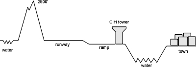
because I'd read that Alaska consists mainly of "dirt" it was no surprise to find some at Ketchikan, but I hadn't expected to find such large piles so close to the approach to the runway. To the side of the runway away from the channel, the terrain slopes up to a 2500 foot mountain, called High Mountain, interestingly enough. So, you'd think this would be just the sort of situation to put the pattern over the channel and away from the hill, right? WRONG! They actually have you doing your pattern against the hill with the pinetrees grabbing at your fuselage on downwind! That's to reserve the channel for the "real" pilots I guess.
Here's a cross-section of the airport area:
The asphalt runway is 7500 feet long, and there's no room for a taxiway. Because the airport is on the side of a hill, the runway is cut in and built up so it's above the airport level by quite a bit. There's a ramp down to the terminal from the southeast end. So if you need to take off toward the southeast, you have to taxi up the ramp to the southeast end of the runway, and then taxi another 7500 feet to get to the northwest end of the runway.
Ever seen an NDB/DME approach? Or an ILS that requires a DME? [DME stands for "distance measuring equipment" that tells the pilot how far he is away from the DME station.] I don't think I'd try to use the Loran with all the distortion from the mountains around here either. No DME? No instrument approach here.
There's also a note on the instrument approach procedure that says in fine print, "Do not allow full scale CDI deflection." [Zero deflection means you're on course, so full scale means way off course.] Morgan a couple of years ago did the approach in good weather and said that if you're more than 1/2 scale deflection you impact the mountains. The circling procedure also is not authorized at night understandably. Note that during part of the year, it's night most of the time.
I talked to flight service later and they said that some commercial jet company that ran 737's into Ketchikan preferred to find a hole in the clouds, spiral the jet down through, and skim over the surface of the water to get to the airport rather than perform the standard instrument approach. I bet they needed to clean the passenger seats pretty often on those flights! Other pilots do the ILS and hold the needle off center so they are farther away from the mountains than if they were on course.
After landing, I was looking for a place to stay, while Steve went upstairs to flight service to check weather. Much to his surprise, he got chewed out for not staying to the left of the channel while we were still aways out from the airport. The field was uncontrolled, which means anything is legal, and we even told them we were unfamiliar with the area but they didn't tell us what they wanted us to do. I guess the macho float plane pilots yelled at flight service, so rather than go home and kick their dog, they yelled at Steve. The problem was that the floatplanes often depart straight out from the channel. All they'd have to do is get the float planes to stay low, and the fixed wings up high.
The bus from the airport to town was $9/person times 8 people was ridiculous. The bus driver was really nice and friendly, even after I whistled at the expense. He explained all our options, slapped me on back, and wished us luck.
We decided to walk on the ferry for $2, and then walk into town. Downtown, and Steve's hotel, turned out to be quite aways, especially when hauling a suitcase. Half way there, we discovered a bus that circulates around town. You just get on for $1, and get off wherever you want. That worked out pretty well.
Several hotels had no room for us, so I was wondering what to do. The hostel didn't open until evening, and I figured I'd have to have a sleeping bag anyway (I'd left it on the plane). I found another dorm place called the Rain Forest Inn for $10 for a dorm room. Meg decided she wasn't very comfortable rooming with another woman in the room, so Steve & Co. took her in so now they had 6 in their minuscule room.
My dorm was conveniently located right near a McDonalds, and was aptly named for a place that gets 13 feet (yes, that's feet) of rain per year. I think most of that comes not in downpours, but in mist. So to get that much water in mist form, means it's always misty.
As to prices, the most outrageous thing I saw was breakfast cereal for $4.50 per box. Cold cuts were $4/lb, about twice down here, but lo and behold, McDonalds was only about 15 cents per item more expensive than back home. You need to use both hands to carry the money for a pizza - $12.
There are a lot of huge tour boats that stop by the towns in the panhandle. The boat moored at the dock was about the same size of most third world countries, and about as crowded with starving people, except they were starving for trinkets rather than food. The easiest way to get everybody back to the boat is to use the foghorn that sends all the tourists for hundreds of miles back to the boat like spawning salmon.
The people here are really friendly, they actually smile back at you while walking down the street - quite a culture shock coming from the northeast and downright scarey to people from New York I bet.
Just to remind us not to get too complacent, the weather is drizzling but the ceiling is lifting and the visibility under the clouds was good. The temperature is rather pleasant, only a little chilly, but everything is damp. It's kind of like being in the ocean, only it's wetter here.
The town is built on the side of the mountain on the other side of the channel from the airport. If you look at the map and go to some of the lines humorously referred to as "streets", you'll actually find wooden steps leading up the hill to a wooden sidewalk. I'd like to see a Ketchikanian lug his car up those streets!
In front of one house, if you opened a sidewalk gate and stepped through, you'd end up sliding about 30 feet down a garbage slide. Many houses are much higher than the nearest real street and have steps down from the front walk to the street level.
The map showed a walking tour through the town with "significant sight" numbers. We didn't have time to take the whole thing, but we did walk to a colorful painted 20 foot totem pole near the center of town. There are other totem poles around, but they're a drive or an expensive taxi ride away.
I spent awhile talking to Jim, the Rain Forest Inn dorm manager. He said that the temperature is far more temperate than I would have imagined. The record low of all time is -4 degrees. Rarely is there any snow in Ketchikan, but the mountains only a few hundred feet up have snow. In the winter, they have crisp, clear days very much like back home. They were not hit by the cold snap last winter. It was surprisingly mild. Northwest Washington state and elsewhere in Alaska and Canada were hit, but not Ketchikan.
The house prices are really crazy because the buildable land is limited. The prices are comparable to back home.
I also talked to a guy staying in the dorm (which reminded me of my old school fraternity sleeping room) who works in the shipyard. He is originally from Kansas and by chance came here. This town is one of the few non-depressed areas in Alaska now. He gets $8/hr and he works a lot of $12/hr overtime. He loves the town which looks like a lower class working town layed out in one dimension squeezed between the channel and the mountain. The main road separates in one place, one direction going around a hill, and the other going thru a tunnel under the hill.
The shipyard worker also told me that after working all day, his socks stunk so bad that the other people in the dorm complained to the manager. So the manager came in during the day, washed his socks, and charged him $1!
There's no smoking in the dorm room, but in a rare fit of tolerance, I didn't tell somebody not to smoke there. His second cigarette was too much, so I said something and he apologized and put it out. The room had about 10 beds in it but only about 4 people when I saw it even though the manager said the Inn was full. Many of the people are lumberjacks in the Rain Forest Inn and they stay at the Inn for a long time. The woman in the room where Meg would have slept had been there for several years.
We crossed another timezone to get here, (4 hours difference to New England) and we're quite a bit farther north so dusk is about 10pm. We are only about 2 weeks after the longest day of the year. Taking a walk after dinner at McDonalds, we notice that it's so wet that the slugs are all over the sidewalk, but surprisingly there are no biting insects in spite of all the moisture. Maybe it's too wet for them. Jim says the bug season is late August.
I stopped in a shopping center and found that I could buy ammunition for the 303 rifle cheaper up here by a few cents than back home. Here it's only $14.25 for a box of 20 bullets. It's a gun lover's paradise. They had AK47 assault rifles and Uzi's for about $800 with no permit required to purchase them. The only restriction was that they couldn't sell a pistol to me because I was from out of state.
The ocean here is incredibly clear, almost like in the Caribbean but much colder. Eagles fly over the channel looking for garbage and are as plentiful as seagulls or pigeons.
The sky had only a high broken layer, so it looks like we can get out of here today rather than be stuck here for a few weeks. I started hitching to the airport to meet the rest of the crew when I saw a policeman at the gas station. I asked him if it was legal to hitchhike. He said the state law says it's illegal, but the maximum enforcement he thought anybody would do would be to tell me not to, so I could then just wait until he was out of sight and hitch some more. Just don't tell anybody that he told me that. He had a huge handlebar mustache and sounded like he'd just arrived from Texas. I did eventually get picked up by somebody for a ride back to the ferry.
Meanwhile back at the airport, the fog is clamoring over the mountains from the west, slashing at the airport, but still thin enough to get out. I went up to flight service in the tower to check weather. By this time I'm sure they've forgotten that we approached the airport the wrong way so I probably won't get chewed out for the unappreciated approach of yesterday.
Hanging from the ceiling is a model of a Boeing 727 with floats attached. It seems that because everything else is on floats up here, so somebody had made the model of the jet on floats. The FAA administrator awhile ago named Helms visited up here and as a joke decided to issue them a formal type certification for the configuration with the Date of Application "Anytime" and the date of issuance of "Why not" and the registration number of R-XX. The configuration was specifically limited to the hauling of fresh fish from Bristol Bay, Alaska to Bald Eagle Creek PA. At least some people up there have a sense of humor. I asked the flight service briefer about the eagles, and he said that in the spring, the eagles get crazy flying all over and create a nuisance. They trap some of the troublemakers and ship down south. They fight all the time in the air and get in the way of the airplanes. That explains the supposedly true story I heard long ago about the mid-air crash of a plane into a fish in Alaska. I guess the eagle dropped the fish when it saw the airplane coming and the airplane hit the fish.
I asked flight service about the rules concerning flying over the Valdez oil spill. The referred me to the "NOTAMS" or notice to airmen. The NOTAM on the spill designated a large area in Prince William sound below 3000 feet which was off limits to all transients.
He showed us approximately where the reef was that the Valdez hit, and showed us the general flow of the oil against the islands. He said that Quayle came up to make an token appearance. They even built him a platform on which to stand so that he wouldn't get his shoes dirty. No rolling up sleeves and doing anything that would actually help for him.
The workers are pretty much wiping the surface rocks and pushing sand over the oil soaked beaches but the oil is still very much there just below the surface. This of course just takes care of the floating portion. The heavier components of the oil sank and are being carried along the bottom of Prince William sound. Maybe Prince William will haunt the arrogant chairman of Exxon from his grave.
As it turns out, because the oil is unrefined, it is biodegradable from bacterial action. Around home, an oil spill takes 3-4 years to be decomposed, but up in Alaska, because the temperatures are lower, it could take many more years to break the oil down.
The weather isn't bad here this morning, 2800 feet overcast, but the overcast is only about 500 feet thick with breaks in the overcast here and there with a visibility of 20 miles or so. However, I began getting nervous because the Yakutat (our destination, half way to Anchorage) forecast went from 30 miles visibility (great!) down to 7 (araugh!). Seven miles is still OK, but 7 is a lot closer to 0 than 30 is to 0. Sitka, on the ocean, was also not very good. Juneau and Skagway (if you lived in a town called Skagway, would you admit it?) were OK, and that was a bit inland, protected by the island/mountains. We decided to go for it with a contingency destination of Juneau, rather than to visit any other interesting towns enroute.
We'll be skipped Juneau the capital, and Sitka which was the old capital of Alaska back when the Russians owned Alaska. We were more concerned with not getting stuck by weather for several weeks at the time than with seeing things.
I talked to the woman filled up the Mooney gas tanks at Ketchikan. She's a CFI (flight instructor) trying to build up enough time to do floatplane flying commercially. She had to travel all the way to Boeing field near Seattle to get her CFI certificate. She said the weather had been colder here than -4 degrees, contradicting the story (maybe put together for the tourists) I got in several other places.
We departed about 9:30am, picking our way through the islands of the inner passageways and staying under the overcast layer because the whole reason for the trip was to see stuff. Of course, below the overcast we'll miss seeing the high mountains along the route. At least everybody thinks the weather will get better as day goes on.
We begin passing glaciers, the first time for any of us. They look like large flat marbled racetracks from up in the mountains down to the water with a steep cliff face over the water. We had nothing down on the water to tell scale, but from pictures I guess the face can be several hundred feet high with icebergs constantly sloughing off. The glaciers are all over the place in the inlets now, with some of the dark bays dotted with white icebergs so extensively that the bay looked much like the dark sky dotted with stars at night.
Every once in awhile, we'd come across a deep turquoise pond in the glaciers. It was a gorgeous, almost unnatural color. That's the blue that supposedly happens from the extreme pressure of the water, but I don't know why it would stay that color once the pressure was removed unless there were mineral salts in the water to keep it blue.
We passed Glacier Bay which is where all the whale spawning movies are filmed. In fact, not far from there, we saw a couple of whales swimming around. We were pretty high so the pictures didn't come out too well, and we didn't want to descend to get closer. If anything happened to an engine, Steve had another one that would take him to shore, but I didn't.
Seeing the whales from above, over clear water was quite interesting. I've been on whale watches around Boston, and have seen whales from an airplane around there, but here, the water was much clearer so you could actually see them dive down. Seeing them from the surface, all you could have seen would have been whatever stuck up over the water, but from above, you could see their whole body through the clear water.
We stayed fairly close to the islands, which were really mountains poking up thru the ocean, but there was enough beach area on which to ditch if we had had to. Also, there are regularly boats around there so we could also probably have ditched next to one of them. There were even several sailboats here and there.
Glacier Bay was already beyond Sitka, Juneau, and Skagway. If the weather closed in around Yakutat we could backtrack to one of those destinations.
Beyond Glacier Bay, there's really nothing until Yakutat. This part of the trip is the most dangerous in terms of the plane going down, where the panhandle meets the main part of Alaska. The high mountains often descend right into the ocean. We mercifully couldn't tell what it was like down there because whatever was down there was under low clouds. We were up high in the clear, and above the first ridge of mountains. Ditching here would have meant landing on the snow on the mountains. I wouldn't have wanted to risk what was down there in the fog bank. And in the clear, high and to our right was Mt Fairweather, all 15,000 feet of majesty.
The higher coastal hills poked up through the fog, and the fog looked thick enough to be a snowy blanket on the mountains. It was a gorgeous contrast, the dark peaks and the white silky covering. It was gorgeous from a nice safe distance in a plane with the engine running fine, anyway.
Just below our level (several thousand feet), the snow rested heavily on the mountains. We could see what was probably huge cracks in the snow where it had slid and had stopped again. Some of the snow was very white, and some was quite dirty. The cracks looked small, but I'm sure they could have swallowed the airplane.
Farther along, the clouds thinned out a bit and we could again see the low ground which appeared to be plains. We went down low again, just over the shore line, and had some more nice views of the scenery, a few hundred feet over the ocean and beach. Steve and I took turns flying through each other's wake. I was generally in the lead because I was slightly slower than Steve.
He noticed that when he flew through my propeller wake, his plane would bank over about 30 degrees if he didn't control it. I was surprised that the wake was that strong, even quite a ways behind me. I fell in behind him and tried it with his 160hp engines, and sure enough, when I hit them, the plane just did a quick bank up to 30 degrees also. I then noticed the passengers - I hadn't seen that shade of green on anybody in a long time.
We skimmed the surface all the way into Yakutat. The clouds were a bit low, but the visibility held up just fine for us. We continued on into Yakutat and landed. It was a good size airport, hard surface, etc. The actual village was 5 miles away or so, but the airport had a lot of buildings there, including a little restaurant, where the hamburgers were $6-9 each! I had a bowl of soup for a few bucks - a much better deal. The place had stuck $1 bills all over the walls, signed by various patrons. No wonder the prices are so outrageous if they have enough to plaster money all over their walls. I never did ask why the money was up there.
Yakutat is near the semi-famous Russell Fiord (competitor to the less well known Russel Diodge I guess). It's a long thin lake that has a very narrow outlet to the ocean. A few years ago, I guess the outlet got plugged up and a lot of wildlife was in danger due to the changing salinity levels. Anyway, the wildlife folks were discussing whether to blow the ice dam out, when the dam innocuously opened up again and the danger was averted.
I was thinking of going up and looking at it on the way out, but I forgot about it and the weather wasn't very good in that direction anyway. Some of the area looked pretty narrow to possibly turn around. If one of the passes were to be blocked or if we'd gone up a blind canyon, we could have been in trouble.
We noticed that everybody was really friendly, like they were actually glad to see *you*, more than because you are spending your money there. Somebody said that you can always tell a stranger because he'll never wave. I guess people wave at each other even if they don't know each other, but the place is pretty small, so I'd imagine that everybody would know everybody in the town anyway.
We depart onward to Cordova, named in honor of the Chrysler advertised by old what's his name with the rich leather. All the way along here, there's a low plain at the shore, very flat, plenty of room to land on.
Even the glaciers are huge and flat. I also saw a round depression, almost a crater, with occasional white rings of snow or ice around it, looking almost manmade. The rings are probably left over from various water levels over the years. The sides of the huge glaciers are muddy and gravely, not at all white with snow. There's so much silt to the sides and it's been there so long there's actually bushes growing out of the silt here and there - sort of like God's dust bunnies from not cleaning up for so long. The ceiling is up and down, but we have no problem maintaining VFR.
Around Cordova, there are green hills, reminds me a lot of pictures of Ireland. We found the road into Cordova and crossing a river. The bridge looks well constructed, with the steel superstructure over the road, resting on concrete pillars. Except that at the North end, the pillars had given way and the end of the bridge was sitting in the water. I found out later that the bridge had fallen during the last Alaskan earthquake 40 years or so ago, I can't remember anymore, but hadn't been reconstructed. The road is officially closed (I'd hope so), but I guess they have made it marginally passable by making another bridge over the huge step left.
We passed that airport without stopping, but we actually saw an airplane in the pattern there. Onward past Johnstone Point VOR navigational station, the weather opens up again so we can have a huge disgusting view of exxon droppings. Johnstone Point is the start of Prince William Sound for our trip and the beginning of our official duty.
I approached the dirty deed and called the controller and asked if we could have clearance below 3000 feet and she said no way below 3000, but had no interest in us if we were above 3000 feet. We crossed the sound, from island to island, and over an appropriate point, we all sent all our frown vibs toward that chief sleezebag himself, the chairman of exxon.
Actually from our altitude (we stayed around 4500 feet), we really couldn't see very of a problem at all. The water and shoreline looked the same as anywhere else and had the same amount of activity as everywhere else - none. When we crossed Knight Island, a couple of the inlets had a bunch of boats and floating booms on the water. From reading elsewhere, I think what they are doing is using hot water to hose down the beach into the water, and the booms keep the oil from disbursing so they can pick the oil up from the surface of the water. However, in some places the oil is several inches deep and by now is hard, so it's kind of like hosing down your driveway trying to wash it away. If the workers stick the hose down into the sand, oil comes bubbling up. We saw only activity in two small areas, as opposed to the vast amount of coastline involved.
The "accident" actually happened about 40 miles northeast of that island and the current pushed all the oil in the direction of the Knight Island passage. Fortunately only 20% of the oil actually escaped from the tanker and had blown away from the salmon spawning beds.
Our official duties now completed, we could continue the trip knowing that we've accomplished just as much in terms of cleaning up the oil spill as our illustrious VP himself.
We proceeded onward to Anchorage. The mountains were pretty high, but we had enough room under the clouds to get over them with no problem. We were carefully following Steve's Loran, when I started trying to figure out where we were by looking at the map. Nothing was making any sense, but both his and my Loran were giving the same information. We weren't really concerned because we had plenty of fuel, and we were guaranteed if we stayed flying straight, we'd come to an obvious body of water, either Knik Arm or Turnagain Arm. We couldn't get off that far. I began hearing the Anchorage VOR and the Big Lake VOR and decide we were considerably off course.
I was trying to relate the VOR readings to the Loran readings, when we broke out onto Knik arm, about 25 miles north of Anchorage. Both Lorans were saying that Anchorage was 60 miles north of where it actually was. The problem was that there were only two secondaries able to be tracked in here. Mine always only tracks 2 stations, whereas Steve's tracks 3 if there are 3 to be tracked. If there are only 2 secondaries to be tracked, his Loran is no more accurate than mine - both useless. This was the only time I remember on the trip that his Loran gave inaccurate information.
Anchorage is an interesting area to fly around. There's the international airport (an ARSA airspace), Merrill field which is right near downtown, Elemendorf airfield about 3 miles north of Merrill, and Fort Richardson, 4 miles east of Elemendorf, not to mention the restricted area area to the north of Fort Richardson. The FAA publishes a whole booklet just for procedures for getting in and out of the area, none of which makes sense to us mere mortals unfamiliar with the area. So, we do the only other reasonable thing to do - call approach control, let them know there are a couple of out of towners around, and have them tell us where they want us.
As it turned out, it was easy. We just headed south along the road until the runway center line, then turned right, and landed straight ahead. Merrill field is incredibly busy with almost as high a concentration of planes as Oshkosh during the EAA Convention. Most of the transient spots were taken already, and the airport was being expanded by quite a bit with a lot more tiedowns in the works.
I tied down next to a guy with a Citabria who's a local, or at least more local than I was. I asked him about the plane and survival stuff, knowing that his plane is about at maximum gross weight with only two people aboard and full fuel without survival stuff, and he said that they really do carry survival stuff, and some people leave behind fuel to get the weight below gross and some people don't. The common saying is that planes will fly when they are over their maximum gross weight, but they won't fly without fuel.
He also spoke of a red salmon run a couple of hours away by plane, probably in the next couple of days. They're so thick running up the river, that you can walk across on them. The river just turns red. The fishermen sometimes catch 2 million of them in one day. Good thing those little buggers are prolific. This is supposed to be a good year for them (I wasn't sure if "them" referred to the fish or the fishermen).
He also told me a bit about the area and made the booklet of procedures more understandable. All we have to know when we depart is that we have to stay below the Elemendorf flight path because we'll probably be departing to the northwest. That means being 600 feet over the river, not a great place to be.
I paid the tiedown for both of us - $3/night. They didn't say I couldn't so I used a personal check. If you don't register, it's a $40 fine plus $6 per night.
Steve rented a car, so we all piled in, though use of the term "piled" implies that the operation was much easier than it really was. The car was one of those small hatchback Chevys and there was 8 of us and baggage. We amazingly were able to get the doors all closed by breathing in sync.
We decided to stay at the hostel in downtown Anchorage, which should put us in the middle of everything. On the way to the hostel, we passed somebody outside the masons, or one of those fraternities for grownups, advertising a benefit spaghetti dinner - $15 per family. Sounds like quite a benefit to us. We registered at the hostel, which wasn't very full, dropped off our bags, and headed back to the cheap eats.
They were just about to close, so we were lucky we got there. The spaghetti and stuff was great for the price. They even had to make us another pan of spaghetti.
After dinner, we returned to the hostel for a walk downtown. It's a really great city down there, with lots of flowers, and a visitors center. However, the center doesn't have any decent maps of the city. But, then, what can you expect about a building with a growing grass roof. I wonder if they ever have to mow it, or maybe they just let goats up there to eat it. There's a high concentration of souvenir shops around. Downtown has lots of vividly colored flowers, both in planters on the ground and also hanging from baskets from the street lights.
There's a little park next to McDonalds with one of those bicycle ice chests selling Hagen-Dazs ice cream. There are a lot of what appear to be bums or street people lying down, and sleeping on the ground. Many looked like Eskimos or Indians. I wonder how they survive the winter. I get back to the hostel too late again, confused by the light, so we get into bed around 11pm which feels like 7:30 or 8pm back home.
Today, we have passed the most spectacular scenery as well as the most dangerous part of the trip. We have seen the panhandle of Alaska and have emerged victorious from the clutches of the weather. The trip almost seemed anticlimactic at this point. With all the stories we'd heard, we were almost too scared to even try it. But then, the planes worked fine and the weather cooperated. By and large, we were quite conservative, and although we did push it a bit, we pretty much always had alternatives, though they could have closed off too if we had been unlucky. Alternatives are like that. There is nothing that is 100% safe.
We decided that it would be neat to see a glacier close up rather than from thousands of feet away. Previously, the closest I've ever been was several thousands of miles unless you count that ice storm in the northeast a few years ago that made the whole northeast one single connected lump of ice.
The interstate road we want heads out of town to the south. However, getting there is not easy, especially considering we don't have anything that remotely qualifies as a reasonable map. I don't think it's the affect of the high latitude on us. The interstate starts in the center of town, but it's one way *into town*. Who ever heard of a one-way interstate? The lights are timed poorly and there are a pile of stop signs. Some streets don't cut through because of parks. I bet they do a booming business on brake jobs.
We finally broke on through to the proper interstate road by using the "drive around at random until we stumble over it or we run out of gas" technique, and followed it up the Turnagain Arm of water and the railroad tracks toward Portage Glacier. The scenery is pretty spectacular with mountains all around. Rumor has it that the tides can be as much as 30 feet, but I didn't notice any evidence that they were.
The glacier had been turned into quite a tourist event, not so much in terms of shops, but a tourist center so new that there was nothing inside but an information desk. Even the plumbing was not hooked up yet. Outside was a riverboat on which they'd take you to the foot of the glacier for about $18.50 per person. That sounded pretty steep to me and none of us went on it, especially because they were having "geological" difficulties.
The 9am boat trip was canceled, due to the fact that there were icebergs all over the place. The boat couldn't get through. They were hoping to have a path cleared for the 11:45 tour. Sure enough, they had this little rubber boat with an outboard motor that would point its nose into an iceberg, then full steam ahead trying to push the iceberg out of the way. The scene reminded me of a person trying to move a house by squashing his face against a window. I thought having a channel cleared for the 11:45 tour sounded a bit optimistic, considering you could almost jump from one iceberg to another for as far as you could see.
As with most wildlife, the glacier was quite shy and had receded so that the foot of the glacier was actually about a mile or two away from where the center was. I guess 100 years ago or so it was at the visitors center, and then it receded (by sloughing off icebergs) a couple of miles (I think the rate was a mile per 50 years). Before too long (in the geological sense) the glacier will be slipping down toward the visitors center again. The glacier sort of cycles back and forth slowly. I guess if your ear were sensitive to frequencies in the range of 10^-10 Hz, they'd be blowing out about now.
The icebergs themselves were gorgeous, many still retaining the deep hue of turquoise blue backlit by the sun. One of the icebergs formed a natural bridge, large enough to walk thru. I guess two icebergs crashed together, and pushed the center portion up in the air.
Fortunately the visitors center was so new they didn't have railings to keep people away from the water so we could walk down to it and pick up icebergs. Steve's two sons jumped onto an iceberg, had their picture taken and barely managed to get back on land because the momentum of their jump had caused the iceberg to slowly, almost imperceptably drift away. Stress on the modifier "almost". Some pieces were as large as a building, but some were small enough to pick up in one hand, but not for long because they're so cold. The air temperature must have been around 50 degrees or so, not bad, but I'm glad the sun was out.
There was a museum nearby that had been there for awhile longer and had some interesting displays inside. It had been around long enough in geological terms for the vocational mutation called "lawyers" to get ahold of it and force railings to be installed to keep people away from the water. Those mutations are probably a result of all that nuclear testing we did back in the '60s. If you're a lawyer, don't take it personally, but we could do without a lot of members of your profession. They could take up something more socially useful, like soap opera writing.
But they did appear to be building a sidewalk at the waterline so maybe it was blocked off for that. I'm glad to see they're keeping the environment all natural. Natural for New York city, anyway. And if that wasn't contrasting enough, they had green dye sprayed on the dirt before the grass could take hold.
The museum had "ice-worms" on display, these 1/4 inch long worms actually live in the glacier and feed on the pollen that sticks to the surface of the ice. There were a bunch more displays showing how icebergs originate, and some displays that talked and some that you poked and some that you rotated knobs.
Back on the road toward Anchorage, we saw a gold mine museum we decided to tour. It was privately owned and cost maybe $2/person, not too bad. If you wanted a can of soda to drink, it was sitting in the stream keeping cold. You could rent a pan and they'd show you how to pan for gold. They had a bunch of old shacks there, evidently there was a panning community with a common kitchen, etc., and a river near by. It was warmer here away from the giant ice chest of the glacier, and the bugs were little flies that bit. The vegetation was incredibly lush for a place that's snowbound most of the year. They have lots of snow in the winter, and it was -35 degrees for over a week last winter during the cold snap.
Down at the river, there were a bunch of tourists doing the panning ritual. The place also had a small dredge going, so I guess there's still lots of gold up there.
On the way back from the museum, we passed a mountain goat on a hill blasted out for the road to go thru, so we stopped (as did most of the other traffic did too) and took a few pictures.
Then we did a quick swing by the Anchorage zoo. It didn't look like too much from the outside to risk the $5 entry fee, so Steve took Alice inside. Their report was not very impressive. The animals were all pretty much native, but not well taken care of. In Anchorage, we had passed somebody's house who had a well-constructed cage in their front yard and kept a reindeer inside that was much better taken care of.
Back at Anchorage hostel, we exploded out of the car for another walk downtown and to look around for a reasonable place for dinner. We found what appeared to be a rustic restaurant, with tables and charcoal pits outside, where they fix up quite a dinner I guess, and it should have been for $17/person. That was quite a tall order, so we found another place at a nice deli downtown. I had some pretty good broiled salmon.
The gift shops are ubiquitous, and one called Grizzley's even had 3 Tshirts for $10. Pretty much every shop had those little glass vials of exxon oil spill. Another place sold shirts that $1 of the money would go to the cleanup.
I saw in the newspaper that Exxon is handing out $10,000 checks to fishermen for compensation. I wonder how one becomes a fisherman in a hurry. I also wonder if they'll be back next year with more checks after the bad press has blown over and the fish still aren't back. The state has closed some fishing areas when they found tar balls on the beach every 10 feet or so in Cook inlet, the opening of which is about 200 miles away from Prince William sound. I guess they want to preserve their good name in fishing circles.
Back at the hostel, Steve called weather and it was supposed to be nice VFR all the way to Barrow tomorrow, so we'll head up there to make sure we've got good weather.
I still can't get over how light it is at 11pm. I'm tired, but not sleepy if that makes any sense. Alaskans must hibernate all winter. It's bad enough in the winter in the northeast when it's dark going to work, and dark coming home from work.
I had to wait for the phone at the hostel - it's one of the more popular devices there, even more popular than video games. The phones are mostly used by mobile yuppies making plans to meet at faraway places like a certain bar in Laos next Tuesday.
The weather looked rather ominous, but ironically, the flight service briefer was quite optimistic, so it looks like we should go for Barrow. It'll be a long day, we'll have to cross almost the full length of the state. We'll stop at Fairbanks just for fuel and push on to Barrow.
Evelyn called Barrow, and there are only 2 hotels in the whole town, the cheapest is $127/night. Well, I think we'll camp if we have to pitch it on the tundra. Right now the weather up there is 700 overcast, and 1 mile visibility, but they expect it to burn off later in the day. We have some options if it doesn't. It'll take us quite a few hours even to get to the Brooks range. On the way up, the weather is forecast to be great.
Near the transient area, they have a clever 24 hour pump for aviation gas. You insert your charge card, and pump the gas. I decided not to use it because there was no oil there, as well as I didn't want to risk it swallowing my card. Just before moving over to an area where real humans pump gas, I met a guy that owned a Cessna 172. Not only that, but he was an airport commissioner. He was great! Not like the Massaport slimebags around here. He said that Merrill field is the 9th busiest of all airports, general aviation or otherwise. The main road is elsewhere and is paved and the gravel road we thought was the main one was a not-yet-finished one.
I called the ground controller from the building where we paid for the gas to find out just how we should go about extricating ourselves from the airspace there, because there's a military field with some big and fast stuff barely north of our airport. He said when we depart, we should stay at 600 feet until we get half way across the channel, then we could start climbing. That would keep us below the F4's and A10's, because they are supposed to be at 1600 feet, but sometimes nobody tells those jet jockeys. And when I got back home, I heard that some Russian Migs landed there on their way to a Canadian airshow (not while we were there).
Amazing! The weather is actually breaking up as the forecast had predicted! The low layers is becoming scattered, so we find a nice size hole and climb up through. Above, it's gorgeous. As we crossed over a more solid cloud, our shadow against the cloud was enshrined by a beautiful circular rainbow.
On this leg of the trip, we pass Mt McKinley - all 20,000 feet of it. It looks very majestic, draped in white robes, with a puff of snow saluting us from the peak. There are several other mountains that are just about as high to the west. We head straight for it and snap a few pictures of each other with the mountain in the background. There are some more glaciers and things in between the peaks. There really was no problem going over the mountains, because to the east they are lower. We did climb to 10000 feet or so to get over a cloud deck, but it wasn't very solid, and on into Fairbanks.
We had a quick turnaround at Fairbanks, and departed with a Barrow forecast of 300 foot scattered (tolerable) and possibly 300 foot overcast (the pits). Currently they are 5000 feet broken which would be great if it stays that way. We decide to go for it. We can make it in one hop, and we will be passing Bettles so we can stop there if the weather goes down. Bettles has great weather, and Barrow is holding up OK. We can also divert to Dead Horse up at Prudhoe Bay if necessary. The forecast is better than Barrow too.
The Fairbanks departure controller was quite helpful, and even pointed out traffic approaching the airport. Unfortunately, I didn't see this traffic until almost too late - another unnervingly close encounter. It was interesting that on my trip across the lower 48, I saw virtually no other traffic for the whole month, and here up in sparse Alaska, I've seen quite a few airplanes in the air, some of which I could almost see the same shocked expression on the other pilot's face as mine probably had.
We had our first encounter with that sprawling monument to American's unchecked appetite for energy, the pipeline. It doesn't look very large from the air. It really is up on stilts most of the time, but sometimes it's underground, and there is a bridge for it over the Yukon river. In one spot along the pipeline, we saw a bunch of (maybe 20) objects that looked just like airplanes, but it was hard to tell the scale. They seemed to be smaller than real airplanes, and were scattered around and some had even crashed into trees. I wondered if they were unmanned drones with TV cameras aboard or something. There didn't appear to be a runway nearby.
Steve is really interested in fishing, so as we pass overhead Bettles, he asked flight service about fishing around there. The briefer was really helpful and said there were several lodges around there, mostly full, but they sometimes have openings. On top of that, many of the lodges have their own discrete aircraft frequencies so he could ask them directly. The river nearby I suppose looks nice if you're a fish. It looked kind of brown to me.
Bettles is at the southern edge of the Brooks mountain range. Past Bettles, there really is only one remote comm outlet (RCO) well on the north side of the Brooks mountain range, so I dutifully gave a pilot report for the weather thru the range after we were out. There were a couple of showers, each about 10 miles in diameter, off in the distance, but none where we were. The visibility was an impressive 40 miles. There wasn't tons of room between the 7000 foot ceiling and the mountains, but there was plenty for us. They really need an RCO in the mountain range someplace.
The mountains were pretty bumpy (as mountains often are), but tolerable. We even saw a good-size rainbow in the showers. I think that means good luck.
The mountains looked very barren, no trees, and only occasional shrubs, and snow in places. We're really away from it all here.
Past the Brooks mountain range, we flew over the area known as the "north slope" because it slowly slopes down to the Arctic Ocean. The landscape is completely flat. There is essentially nothing from the end of the Brooks range to the ocean, no trees, shrubs, nothing visible from the air except for an occasional shedded moose antler, showing white against the green tundra growth. For most of it, we didn't even see birds.
The ground is incredibly flat, laced with water blood vessels, and an occasional pool here and there. We swooped down on the deck, and there was still no sign of life at all. The whole basin north of the Brooks range is an old ocean bed. The lakes become elongated in some places as the water drained out as the seas receded.
There's only one RCO (remote communications outlet thru which you can talk to flight service) along the way to Barrow. That means much of the way you're out of touch with anybody.
As we flew over this part of the tundra (probably Eskimo for "vast nothingness"), the surface looked solid. But when I looked at where the reflection of the sun would be if the surface were a mirror, I could see the glint of water everywhere so the ground must be incredibly mushy.
After 100 miles of that, we came upon the giant sponge portion of the tundra. There's more lakes than land, just like a sponge with the holes being the water ponds. Some were quite big, on the order of a mile or so, but most were 1000 feet in diameter. I'd hate to have to pilotage and figure out what lake was which. I also wonder if the lakes don't change from year to year. At Barrow, we found out that there's quite a bit of fish in these lakes, surprisingly enough, considering there's permafrost underneath, and in the winter, snow above.
In the "great sponge" area, we passed over interesting oval depressions in the ground that except for their shape, could have been meteor craters. It turns out they are prehistoric burial mounds and it's illegal to dig around them.
Off in the distance, appeared a hill or mountain or rising land, but there's not supposed to be anything like that. As we approached, we could see that it was smoke from the Barrow dump blowing pretty well. What a way to be greeted by our destination of such distance, but it is a good metaphor for the town.
I was happy to see it meaning that the weather was far better than the forecast so we had no trouble finding the airport. Barrow was small, but really the only town around. We swooped over Barrow and the Arctic before coming in for a landing.
The arctic was littered by icebergs everywhere. They were all over the place, with no obvious source like was the case at the glaciers.
The first part of the runway was painted white as opposed to the normal asphalt. I thought it was a displaced threshold, but later I found that it was some experimental paint for the runway. The flight service briefer was very helpful (as usual in this state) although there was no other traffic to warn us about.
The weather was rather chilly when we got out, about 45 degrees. After we landed, an older couple from Rochester, NY, arrived in an Arrow. We all sort of bundled up. My wool hat came in very handy.
The taxiways here are fine gravel, so we tried to be careful taxiing. The stones would love to jump up and clink with the prop. We fueled up, and then found that they take only cash at $2.50/gallon for 100LL. Fortunately, I came prepared and so I was able to pay for Steve's gas too.
Shortly after we landed, we I met Dano, the airport manager who also took pity on us. He lives in the fire building because he's required to get to anyplace on the airport with his firetruck within 3 minutes of being called (FAA regs for commercial air service). He said we could camp anyplace, and we could use his bathroom and shower. Inside his garage/living quarters are lots of fun toys - a firetruck and a huge snow removal machine. The floor is gravel. He said that the floor was asphalt at one time, but it sank into the tundra, so they just filled the hole in with gravel. The whole airport is fill on top of tundra - about 10 or 15 feet of fill.
We walked to the "Airport Inn". Actually the whole town is easy walking distance. The Inn looks like a barn on the outside with the standard plywood motif, but the rooms are nice, and they have a microwave and refrigerator. For $127/night, they ought to have gold plated false teeth holders.
From there we checked out the visitor's center, and passed some Eskimos cutting up seal blubber in their front yard. Killing seals is illegal because they're endangered, but the Eskimos are still allowed to kill them because it's their traditional food, etc., however, they've incorporated the white man's efficiency into the process. We saw a seal being cut up in front of one of the houses so I guess it's pretty common. The Eskimos just go down to the beach and shoot one and drag it back home. I hear they are plentiful, and the Eskimo can get $500 for one, but at the beach, we didn't see any, which was good, because they probably would have gotten shot.
We spoke to the woman at the visitor's center. She is from Pittsburgh no less, and came here to live with relatives and save money. The center has some nice Tshirts and a map of the town, a far better map of Barrow than the Anchorage visitor's center had of Anchorage.
The visitor's center also has hanging up, a gorgeous picture of one of the whales that were trapped up here last winter poking his head thru the ice. That's the event where the president spent more money than many small country's gross national product to save the trapped whales, making the decision within sight of where humans are sleeping and starving in the street. We have a president with "interesting" priorities.
The streets up here (this town is "up here" from pretty much anywhere) are all gravel and dusty. Lots of people have ATV's (like 4-wheeled motorcycles from hell) and scream all over town in them. Most cars are busted up wrecks sitting in yards. I saw one nice Firebird. I wondered why bother having a nice car up here? We also saw a forklift truck carrying a dead car down the middle of the street. I can't imagine where he was going. He could have just dropped it anywhere - it wouldn't have made any difference.
We also saw the "Barrow Natural Forest" It's this telephone pole with some plastic leaves nailed to the top and a sign explaining that it's a rare "Snoconut" tree and bears snoconuts in December and January.
We swung by flight service to check weather and ask about the town. He told us that the weather depends far more on the direction of the wind than the specific highs and lows. It could be nice for the next couple of days. He used to be an LA controller and now spends 3 weeks in Anchorage and 1 week in Barrow. He said he works 7 days a week. He must get some kind of overtime.
The briefer also suggested walking to the bluff overlooking the ocean and watching the Eskimos catch and shoot seals. Watching doesn't sound fun to me, I'd rather be there when the Eskimos aren't there killing seals. I mean, I eat meat too, but I'd just as soon let somebody else kill it for me.
Because the sun is up all night, the night isn't much colder than the day, only about 5 degrees or so. It's weird to be talking about night when there isn't any. Night is merely an artificial temporal boundary; digits on a watch.
The weather here in general is much more temperate than inland because of the ocean holds the temperature of the land nearby more constant. It sometimes gets up to 20 or 30 degrees in the winter, and it's usually not below -20 degrees, but it can get to -50 or so for a week.
The town has only 3 restaurants, but we have lots of camping food to use. I bet the restaurants are as expensive as the hotel.
The temperature while we were there ranged from Tshirt weather when the sun was out with a slight breeze to wool hat weather when the clouds were in front of the sun and fog blowing across the ocean - quite a drastic difference in the space of a few minutes. I kept putting on and taking my coat off like I was in a clothing store trying on different coats.
The sun appeared to me to be about the same angle above the horizon even though I know it did change as it rotated around overhead. The weather does seem to vary a bit between night and day though just like back home.
There is lots of standing water down on the tundra. You can slide the 15 feet down the side of the filled runway and taxiway, for a blood-sucking view of the tundra, protected by the attack mosquitoes.
Going on the tundra is like saying "Come and get it" to the mosquitoes, though it's still far worse in my backyard at home. All you have to do up here is swat regularly like you have a strange muscular tic.
We're still not sure what to do for sleeping, I walked back to the plane, looking for someplace slightly conducive to tenting. The tundra is no good because it's too mushy. The gravel is awfully lumpy and hard.
That's when we met Jim, the deputy commander of the Civil Air Patrol squadron up here. The squadron is named "Farthest North Squadron", and even made the CAP newspaper awhile ago, when there was a picture of one of the last L-19 birddog airplanes CAP owned on the cover of the CAP news, and that picture was taken right there.
He showed us the CAP squadron building, a one room shack, but well equipped with radios and a heater that would drive you out of the building at full blast. It had a floor and a roof, and he said we could sack out there for the duration I loosely term "night". The squadron had some nice radio equipment, both low band and VHF. He flies a Cessna 180 out of Barrow, although most searches are initially done by professional search and rescue people, and the CAP gets called out to do visual searches. Their territory is everything north of the Brooks range. That's HUGE! It must be like 200 miles by 400 miles.
He also said that up there, if you're incapacitated in a crash and there's no ELT, you're about done for, especially in the winter. Because most planes are white, finding a white plane in the white snow is impossible, especially because it's dark all the time in the winter.
He also pointed out that there are numerous navigational aids as well as airports that aren't charted on the maps. One runway is so big you can land jets on it and it's not marked. The oil companies even have private ILS (expensive instrument landing systems for bad weather) approaches up near Prudhoe Bay.
He said that sea fog socks in the Barrow airport and an area within 4 or 5 miles of the coast, but beyond that inland, it's gorgeous. If he wants to get into Barrow, rather than fiddle with the ILS instrument approach, what he does is descend to water skimming level, follow the coast up and at the right place, turn to head to the airport with a special VFR clearance. People scud run a lot here because there's really nothing to hit on the tundra.
Getting out of Barrow isn't too bad either - if the weather is lousy, you can get a report from the commercial operators what the weather is up above the fog. If it's nice up there, you can get an IFR clearance to pop thru the fog, and emerge into the clear conditions above the fog.
The tourist season is big now, with about 8000 people per year visiting. The regular 737 service to Anchorage, is about $300 one way, so you have to want to come here pretty bad. It's interesting to say you've been, but that's about it.
Tomorrow there will be an Eskimo crafts show put on for the arrival of the tourist flight. So that and visiting the Arctic ocean, is about all there is to do up here. You're really pushing it to spend more than a day here.
I wandered down the road parallel to the airport - there are a lot of buildings and hangars, including a fairly modern small commercial terminal. There is bus service around town. The busses all say "BARROW" like maybe in case there was somebody waiting for one that said "CINCINNATI"?
Back at the CAP building, this lack of night is confusing. The sun is still bright and shows no sign of ducking below the horizon. The clouds are breaking up nicely. We have a late camping style dinner, and get into our bags around 10pm, at least that's what my watch said, even though my body and the sun differed. It's sort of like flying on instruments, because I had to believe my watch and go to bed at the appropriate time and ignore my body telling me to stay up.
violate you on the catch-all "reckless operation" clause). The guy up there is quite talkative. They have a guest book for pilots to sign in so I did so. I only had to turn back about 4 pages to find Morgan and Deb Robinson's name - friends that were up here 3 years ago.
The briefer also told me that about a month ago, a guy from Hollywood Florida showed up in a Bonanza, for a flight nonstop over the north pole to Helsinki. He made it in 22.5 hours with about 26 hours of fuel aboard. Assuming he used 15 gal/hour (probably more than that), that's 390 gallons or 2340 lbs of fuel! (Can you spell o.v.e.r.g.r.o.s.s?) The guy took over 4000 feet to lift off he was so heavy. He ended up breaking 2 world records, not to mention a few FAA regulations on aircraft loading.
In an interesting sidenote, a month after I got home, we borrowed some old newspapers from the neighbor next door with some land in Florida. The newspaper happened to be from Florida, and had an article about the guy. He departed Barrow for the pole, and was warned that there might be water in his gas tank. He elected not to return and check it out because he would have been too heavy to land. I hope he tried running a bit from all of his tanks before continuing. He also used a sundial to navigate over the pole.
A stroll into the airport terminal showed a wall full of business cards of businesses in Barrow. A particularly interesting one was from the "Elephant Pot Sewage Pumping Company" with the boast "Helping you clean up your act, 'cause we got our shit together." You don't see ads like that in the lower 48!
The native Eskimo activities was scheduled to start in one of the commercial terminals shortly, and as I walked toward the place, a 737 landed, disgorged its human contents into busses (that said "BARROW" of course). The busses arrived at the hall and the Eskimo show was precisely timed for the arrival of the tourists. The participating Eskimo's were of all ages, young and old, but I could see quite a difference in the initiative level. The old folks were really getting into it, but the younger ones really didn't have their heart in it and I don't remember seeing any teenagers. At that rate, I wonder how much longer the ethnic knowledge will continue.
The show included some dancing as well as a quick demonstration of how women sew anything that moves into something to wear, though I didn't see any mosquito underwear or anything. They had some gorgeous parkas, and even mukluks, or boots. Some of the women taught their trades in the schools, but they didn't mention any younger people making anything.
The show also included something that I saw in Australia too. I can't remember the name, but it was a flat, oval shaped piece of wood about six inches by two inches with a string attached at a narrow end. You let it hang down and twist the string a good bit. Then you swing the whole thing around. As the string untwists, it twists back the other way, and back and forth, making a sort of constantly changing pitch buzzing noise. It's also featured in the movie Crocodile Dundee II. It's quite interesting that two places so far away from each
other would have the same device. In Australia, it was used to ward off evil spirits before a ritual. I wonder if it works on fog.
The show didn't include the traditional blanket toss, which originated from a very practical exercise in the old days. Seeing as how there were no trees to climb to see if there was anything worth killing nearby, and photo reconnaissance satellites hadn't been invented yet, they'd get a light person to stand on a blanket, and everybody else would gather around the edge and all together toss the one guy up. It's sort of like a turbocharged trampoline. At some point, they made the blanket toss into a competition, like who could get their guy into orbit first.
Walking around toward the the beach, we passed "Arctic Pizza" and I should have found out how much it costs. At the beach, I Sue took my picture sticking my toe into the Arctic Ocean. It's as cold as you might imagine with all the icebergs floating around. And remember, it's salt water, so it's probably well below 32 degrees.
Surprisingly enough I saw quite a large jelly fish, about 6 inches in diameter, just lazing around. I didn't realize they'd live in such cold water.
To get to the ocean, we had to actually clamor over big piles of ice. The beach actually was not very inviting, with lots of trash around, and the grains of sand were more like pebbles. To get to the beach, you had to climb down a cliff from the tundra above.
Walking on the tundra was quite interesting; it was like walking on a giant firm mattress, because it was slightly springy. There were lots of tracks of 3 and 4 wheeled all-terrain vehicles - sort of like motorcycles with too many wheels. Where they had gone, the track was mud, but the mud still felt spongy.
On the way back from the beach, between the beech and the road, we saw what I thought was the stump of a tree six or seven inches in diameter, but it turned out to be one bone from the backbone of a whale! I wonder where it came from; maybe it washed up on the beach or something.
We walked around town and saw the most modern building up there was the Alaska state court building, a sad comment on what society considers most important up there. We stopped into the museum near there, which turned out to merely be a large room which also served as the atrium for whatever offices were in the same building. There wasn't much stuff there, mostly ethnic things made by the Eskimos there. Out front was a huge jaw bone from a whale large enough to stand in.
I guess warm temperatures like we saw were rather unusual, because everywhere the heat was still on. However, if they were to leave the heat on, it'd get too hot, so they use what I call the "Ronald Reagan memorial method of temperature control" in honor of its stupidity and wastefulness - they open the windows! That's right, just let it go out the window. I guess Lester Lightbulb hasn't made a hit up here.
We met back at the airport, but by this time, the visibility was dropping a bit, but we could still get out so we loaded up the planes. In the time it took to get the planes cranked up, the fog turned so thick we had trouble seeing 100 yds. Boy, that stuff comes in fast. We decide not to ask for a special because we really don't know what's beyond (though 5 miles away it's probably fine) and they're saying the ceiling is only 2400 feet, so we shut down and go to lunch at the Burger Barn. A couple of locals at flight service said that this sort of thing just happens now and then, and it'll blow off in an hour or so.
The Burger Barn is the closest thing to McDonalds, except your money probably doesn't go to the Moral Majority scam, but a standard burger with no options is about $4. Their placemats say "Our Buns have more class". The other interesting thing is that the drive in window is about 15 feet up above the ground now that there's no snow.
An hour later, the fog departed as quickly as it came, so Steve and I head to flight service, and the rest of the crew head back to the plane. Because there's a fence around the airport to keep the Moslem extremists from hijacking anything (have you ever heard of a Moslem hijacking anything from Barrow? No? See how well it works?), the rest of the crew try to cut thru one of the businesses straddling the fence. It turns out a lot of people live in their businesses and they ended up bothering an understandably irate inhabitant.
We departed for Fairbanks even though the enroute forecast isn't great over the Brooks range, but the locals have shown us the Anatuvuk pass just east of the straight line distance to Bettles and Fairbanks. Steve's Loran was incredibly helpful at finding the right nitch in the mountains, though I was cross checking with pilotage constantly. The nitch we were looking for was about 50 miles west of the Alaska pipeline nitch.
The weather is not great, but we stay in constant ground contact all the way. As we approach the Brooks range, the clouds are much more solid but much higher, so we won't have any problem with the pass. The only tricky part is making sure we follow the pass and don't turn off into any blind canyons. The pass is wide enough to turn around anywhere in it which is why we feel OK about trying the pass in possibly marginal weather. There's no remote comm outlets here either thru which we could ask about weather. Once here, you just grit your teeth and go for it. There is an airport with a 5000 foot runway just at the start of the pass called the Anatuvuk airport in case we really get into trouble.
On the way to the Anatuvuk pass, we passed at least one large runway that's not on the map, just like the CAP guy told us. That's really poor of the charts not to have all the airports on there, not only for emergency landing, but also for navigation, so a pilot can figure just out where he is.
As we passed over the Anatuvuk airport, some twin whizzed right between Steve and myself at about our altitude. It really rather shocked us - another too close encounter. Well above us was a DC-3 at probably 5000 feet above ground, running just under the solid cloud deck. The visibility was about 10 miles, with the mountains extending up into the clouds on both sides. The turbulence was pretty bad in the mountains, probably the worst on the whole trip.
We got to one point in the pass, where it was obvious where we wanted to go on the map, but less obvious in real life where the prop hits the air. We ended taking the right fork and then deciding a few minutes later that it was wrong, but there was still plenty of room to turn around, retrace our flight, and proceed back down the right left fork (did that parse OK?).
There were random outposts of civilization here and there through the pass, but no roads and only an occasional airport. It's really curious how the folks there survive not to mention how got there in the first place.
We made it through the 60 miles of pass OK, to Bettles with its gravel runway. Steve decided he didn't want to fish THAT much, considering the risk to the propeller with gravel and all that. Bettles is the pretty much standard stopping point for people that don't have enough gas to get all the way from Barrow to Fairbanks on one tank full, so we pressed on without stopping.
The weather sure didn't look like the reported 5000 scattered; it looked more like overcast to me. I guess flight service doesn't look out the window much here either. And there were thankfully no thunderstorms as the forecast said that there might.
The pipeline runs fairly close to Bettles and ran to the south in our general direction, so we followed it back a little ways over the same path as we had taken to get up to Barrow. We managed to find the curious crashed plane-like objects as before.
I circled for a picture, and Steve continued on unencumbered by my slightly slower Mooney. I heard him talking to the Fairbanks approach controller concerning an ELT being received. I got to about where Steve was, about 40 miles north of Fairbanks, and I heard it too. I could dip the plane and hear the signal change strength, but wasn't sure of the location of my antennas relative to the wing. If the antennas are on top of the plane, for instance, and you bank left, if the signal is coming from the right, you'd get a null because the wing would shield the signal from the antenna (if the antenna is mounted in line with the wing).
So anyway, I couldn't even tell from which side of the plane the signal was coming. I didn't want to take the time to chase the signal then, because we'd been flying for quite awhile. At this point we were beginning to be in a fairly stressed physiological state, and if we didn't land pretty soon, the cockpit would have been uninhabitable without extensive cleaning.
We uneventfully landed at Fairbanks, and I went in to flight service to report as accurately as I could the position at which we heard the ELT. It turns out there was a report of a distress call from a Cessna 207 cargo flight from Ft Yukon to Nenana (just southwest of Fairbanks). Because it'd take an hour for the Civil Air Patrol to get airborne, we decided to take Steve's Apache up and see what we could find. We had just gotten the engines started, when Evelyn came running out to tell us that somebody had already found it and the pilot was up and walking around so he was OK.
I wonder what customs would do in this case. They guy had crossed the boarder and had landed without being available for inspection by customs.
We rented 2 cars and drove to the hostel in Fairbanks. It turned out, not only is this hostel pretty well away from the downtown area, it's a big Quonset hut, with a divider down the middle. He didn't say what they divided, maybe short people on one side, and tall people on the other. Also, the bathroom and showers were aways off, all for $7 per person. Steve decided on a hotel for $40 per night was a better deal. On the way to the hotel, not far from the airport, was a bikini-clad person advertising the hotel. The hotel seemed to be OK, and if you had insomnia, you could walk across the street to a topless bar for some entertainment.
We opted for the free campground at the airport. It's free for the first 3 nights, then $3/night after that with a maximum stay of 7 days. The maximum was probably set at the tolerance limit for people camping without showers to prevent having to fumigate the area.
The water came had to be hand pumped that tasted like you were sucking on a rusty doorknob, but the price was right. There was a "honey pot" I think they called them, those buildings that have a moon cut in the door, and a large roof over about 4 covered picnic tables. One of our tents was free standing, and nobody else was there, so we pitched it under the roof. The other tent required stakes, and so had to be pitched on the ground, but from the hardness of the gravel ground, we might as well have been trying to put the stakes in the concrete. I didn't taxi the plane down because the gravel was pretty loose. It was not rough, but the prop could pick up a stone easily. There were tiedowns there, but no ropes. I left it tied down about a mile away near flight service.
As to showers, many people camp or are in cabins without plumbing I guess, so the Laundromats here have showers for $3. I suppose you can wash all your clothes, at the same time as washing yourself too. It's kind of neat at the Laundromats, as some comedian has said, because you get to see people in the clothes they hate.
At the end of a long and light day, it's now 12:30 in the morning, the sun is no longer up, but it's still very light. There was a slight sprinkle, but nothing substantial. Fairbanks has the most mosquitoes we've seen on the trip or will see anyplace but in my backyard at home. The mosquitoes aren't really that objectionable and so I don't bother with any repellent. Sue found that incense sticks did a remarkable job of keeping the mosquitoes away.
There's an interesting taildragger parked around the side of the hangar with no wings. It has the largest tires I've ever seen on a plane - they must be tundra tires. They were 35x15-5.00 so that it can land on the tundra and not sink in. With those big tires, it could probably land on water. The tail wheel seemed to be the same old size as it would be back home.
We do a bit of shopping downtown, and return to the shelter, where a guy named Ray had arrived to camp with a Cessna 205 from Gainesville, FL. He's a professor of math which is a sub department of the Computer Science department down there. That's a switch. Back when I went to school, there was no Computer Science major for undergrad. If you wanted it, you had to major in math.
Anyway, he was traveling with his deaf and almost blind dog that barked whenever it saw red. Ray had some friends flying up commercially to tour the countryside with him. That sounds like a great deal to me, to have somebody deliver a plane up there to carry me around in for awhile. It'd be especially useful for them coming from Florida, because it's quite a bit farther to Fairbanks from there than from where we had come. His plane had an oil leak and he was concerned about getting it fixed before going on.
A 172 must have arrived while we were gone also. It was tied down over on the other side of the camp, and far enough away so we never saw the occupants. They were carrying a couple of bikes and I guess were already in bed. With all the light, people can coexist with entirely different sleep schedules or coming from completely different time zones and everybody can be awake while it's light at different times.
We also walked to the float plane pond, which was parallel to the other runways. There must have been maybe 50 or 100 float planes tied down with room for about twice that many. A lot of them had fuel tanks up on land to refuel the planes. I don't know why they didn't just use the fuel trucks, unless it was autogas and they contracted for their own truck, although I'd think the airport would like a piece of the action. Airports are generally like that.
It's sure hard to imagine that in six months everything will be cold and snowy. And speaking of weather, I went to check on it. Interestingly enough, there's a low sitting right on top of Ketchikan, but the weather in that whole panhandle area is completely clear.
That would have been neat to see, but we just didn't hit it quite perfectly I guess. It was amazing that back home, that low would have meant cloudy and rainy weather.
The flight service briefer said that there was an occluded front over Nome, which is on the far western tip of Alaska, and it was causing bad weather there, but they didn't know when it would get to Fairbanks. It was strange, that back home, it's usually easy to forecast when a front will hit. Well, at least the weather people take a stab at it. They just figure the distance and the speed, and you have it. Out here, the state is so big, and the weather so unpredictable, that a lot can happen to weather over several hundred miles, and it's probably about 400 miles from Nome to Fairbanks. I said, "But it's only one state, how long can it take to cross?" The briefer looked at me appropriately strangely.
Another shop had a standing, stuffed, Kodiak bear. I think I read someplace that the Kodiak bear is the biggest bear and I could believe it. The head was about 8 feet high standing up and reminded me of a furry cement truck doing a wheelie. If we'd met up with one that had all it's innards working, it'd be quite a challenge for the 303 Enfield rifle that I had.
Alaskaland had a merry-go-round, and miniature golf. They also had an original riverboat with the woodwork being beautifully restored. It was incredibly huge! They had lots of people working on it. They had actually floated it here into a depression from the nearby river, then they drained the river.
The Alaskaland had lots of old machinery used for gold prospecting years ago, including big dredge buckets and an old mobile sawmill - a sawblade fitted to some old pickup truck, I suppose in the model T vintage, but I'm not really up on cars like that. Most of the cars I know about were still in the form of iron ore when I was in kindergarden.
I talked to a woman who ran one of the food shops. She had a journalist friend who had just come back from Prince William Sound. He had the opportunity to ride both with the conservationists and the exxon people (I use the term "people" here loosely too) and so he got a pretty well rounded view from both sides. His opinion was that Exxon was still really dragging its feet on this whole thing, not that we really expected anything else from those corporate slimebags.
From there, we went to drive around downtown. Fairbanks feels unconcentrated, much more like a large town, rather than a city like Anchorage. The downtown area is fairly small, and the area covered by development is rather large. The housing near the downtown area was not in very good shape either.
A river runs through the center of the town and there's a nice visitor's center and a milepost to various other places in the world. There were also some folks setting up for a kayak slalom next Tuesday. They hung these colored poles suspended just above the water as gates for the kayaks. A pair of poles of one color, meant the kayak would have to go through upstream, and a pair of another color meant they'd have to go through in the downstream direction.
A little bit downstream was an Eskimo fish wheel I think they called it. The device looked like a large waterwheel, with a fishnet connected where each paddle would have been. The wheel just scooped up some water and (hopefully) fish, and dumped the fish out on the downward part of the cycle.
We did a bit of walking downtown, and all
the shops seem to be selling the same little glass vials of exxon oil.
They'll get rid of it all yet! There were some interesting shops around.
There are a lot of posters and Tshirts available saying "Drunk drivers
are breaking Alaska's
The shop business seem very slow here today to me, but about average for mid week. I asked some shop keepers about whether they thought the Exxon spill caused a lot of tourists to cancel their plans as I'd been reading, but the shopkeepers I talked to said they thought it was an average year. They didn't really see much effect from the spill.
The schedule is tight for tonight. There's a "Photosymphony of the Northern Lights" we want to see, we have to shop for dinner, return the car, and get back to our tent site without a car. The photosymphony was about 20 miles away. I really wanted to see something about the northern lights up here, because that was one thing we couldn't see because it was so light all the time. I've never seen them, though I'd heard that they were spectacular last February back home, but that was right as I was being sent by DEC to Sydney Australia (yea, I know, it's a tough job...).
We cruised off to the photosymphony at the firehouse theater in Ester, a neighboring small town. It turned out to be an actual old firehouse, with the inside painted pitch black, with a wide screen up front. The artist, LeRoy Zimmerman, gave a 5 minute talk about the lights, and how he photographed them.
Capturing the lights is quite tricky. First off, they are bright against a night sky, but not bright enough to be able to take an average snapshot. You have to open the lense for a time-exposure. But the lights can be constantly moving so all you get is a smear. So you just have to take lots of pictures, and hope a few come out. I guess scientists have been able to take moving pictures with a lot of expensive apparatus, but that's far beyond the reach of us mere mortals not on a stupid defense initiative budget.
In his talk, he said that the best way to observe the lights is to rent a cabin off in the woods someplace in the wintertime, away from the cities. He suggested as a further aid to seeing the lights to get a cabin with an outhouse outside rather than indoor plumbing.
The northern lights is quite a widespread phenomenon. Often it can be like a crown on top of the globe, or as a vertical curtain of light in a circle centered around the magnetic pole, thousands of miles in diameter. From the perspective of a person on the ground, there's a ribbon of light stretching from one horizon to another. LeRoy rigged up three cameras rigidly held together and carefully synchronized so that the edge of one picture from one camera met well with the edge of another picture from another camera, etc. Then, by displaying all three pictures on three slide projectors, he was able to show a much wider picture. The lights he had captured were quite spectacular, being shown to various music pieces (the audio portion of the symphony).
His syncing of the three slide projectors was excellent. All you could see was 2 slightly dark fuzzy vertical lines in between the pictures. He had two banks of projectors so that he could cycle between the two sets so we wouldn't get the big dark interval while one bank was cycling to the next slide. The syncing between the two banks wasn't quite on, but that was the easy part to get synched.
In his opinion, the best month in Alaska is September because you have some darkness, but it's not really cold yet, there's no snow, and you get to see the fall. Part of his show was the fall season, and that also was quite spectacular, but we see that back home also.
Tomorrow we push on probably to Dawson City. We have to stop at Dawson because Meg has been studying it in school and has also studied Jack London who lived there. Steve is less interested, so we make plans to just meet up in Whitehorse the next evening. Steve's two sons went off camping alone in the woods and plan to wake up and hike back to the road to be picked up at 10am. As it turned out, they were so tired that they slept thru their wrist alarm, and were woken up by the sound of A-10 jets screaming at them from treetop level and were late returning to the pickup point. That of course messed up more schedule so they flew directly to Whitehorse and arrived only 10 minutes after us, when we stopped at Dawson City, but that's getting ahead of things.
The refrigeration system sounds like good planning on the architect's part, right? Well, just to preserve the balance of stupidity, the building also has aluminum ladders for climbing on the roof. The ladders extend above the height of the lightening rods.
The briefer also spoke of the very short growing season here, even though it's light all night long in the summer. The trees are quite small because the roots can't penetrate the permafrost and so tend to grow out along the ground rather than deep down. You can tell by the top new growth of the tree how much the tree grew in a year. The south side of hills have more growth than the north side, for instance.
We departed alone this time for the first time this trip. We heard a Lear jet reporting what appeared to be a plane down about 15 miles to the south of the airport. There were no planes overdue, but some military jocks were out and found the plane. I was out of range before I heard the results.
Because the flight would cross the boarder into Canada, I opened the required flight plan and the ADCUS, which tells flight service to notify the customs folks that we're coming.
We followed the Robinson highway away from Fairbanks, but eventually the name changes to the Alaska highway. We followed it down to the Big Delta VOR to stay out of a restricted area, then directly along the latitude line to Dawson City. Because the folks up here haven't seen fit to paint the latitude lines on the ground for us pilot folks, we had to pilotage again, but this time without the comfort of Steve's Loran. The pilotage worked out great, and we were "spot on" as they say down under.
Our ground speed was 135knots, so we had a slight headwind, and we passed the checkpoints right as expected. There is even a road now and then marked on the map. About 50 miles from Dawson, we came upon a huge cloud which turned out to be smoke from a forest fire blowing south across our path. The briefer told me later that the smoke was so bad the previous day, I probably wouldn't have found the airport.
I called into the airport for weather and asked them to remind customs I was coming. Reminding the radio controller at an airport that you need customs is always a good idea. The custom folks never like to be caught by surprise. They like to be standing there as you taxi in so that you don't have any time to do anything subversive before they inspect you.
Dawson City was still reporting 15 mile visibility, so the smoke must end shortly. I climbed to get over the smoke, but still wasn't over it when I decided that it wasn't worth topping it because we'd have to dive to get into the airport, especially with gas $3/gallon, not to mention shock-cooling the engine. The visibility was poor through the smoke, but still VFR. I was concerned about even finding the airport, but within a couple of miles, we were through it and back out to good visibility as advertised. And the airport has an NDB radio beacon on the field for navigation so that made the navigation easier too.
There was Dawson City, nestled between the Yukon river, and the rising mountains. But the airport was another 10 miles or so up the canyon. The river banks in the canyon looked as though a giant mole had been digging around in the river bed with scalloped gravel all over the valley. I'll have to remember to ask somebody about that later.
The trip up river to the airport took longer than it seemed it should from the map, but I keep forgetting that I'm still using a WAC chart and everything looks closer together on those large scale maps.
I landed straight in on runway 02 into a slight upgrade, onto gravel as advertised. Hmmm, it's been a long time since I've needed soft field procedures. I held the nosewheel off as long as possible, but the elevator on Mooneys is not very large. The surface was quite smooth and felt pretty hard except for all the pebbles we were rolling over that would love to jump up and ding the prop. It sounded like I had square bearings in the landing gear.
I parked in front of the only building, not far from a gaggle of fire fighting planes. There was one huge 4-engine DC-6 with red goop all over the tail from dumping it on fires, and a bunch of modified submarine chasers for the same thing.
And in front of the building was the customs agent, smiling no less! I didn't think they were allowed to smile. It was quite a contrast to Ms Nasty in Seattle. At that point I realized I'd forgotten to bring even a scrap of ID for Meg. The custom's lady was super. I put my head next to Meg's and she allowed as how she could see a resemblance. My pilot ID was good enough ID for me.
I reported our grapes, which at that point looked more like raisins still on the stems, but she said they're only interested in fruit with pits.
Then she asked the biggie, "Do you have any firarms?" I said yes. Uh-oh, here is where I flunk the "how to dissemble the gun" test and get deported in disgrace. No problem, she just wrote "rifle" on the customs slip. She'd never even heard of anybody wanting a pilot to disassemble a gun. She asked me if it was loaded, more for my own protection, but never wanted to look at the gun.
I asked her if anybody inspects planes for the necessary survival equipment and she didn't know if anybody ever did. Customs doesn't care if you go down. Maybe the Canadian FAA would, but it's not her department.
I told here we were bound for Calgary and the Stampede and she fairly bubbled over with excitement about us going there. The Stampede is a famous and huge fair with rodeos, etc. Steve has a friend that lives in Calgary and we're planning to drop in on him.
I asked here about getting into town, which was quite a haul or a large taxi fare, and she yelled over to a guy named Larry and asked if he was going into town if he wouldn't mind giving all of us a ride. It worked out great! For the return trip, we could call the fuel people and get a ride out with them. The fuel folks don't stay at the airport, they stay in town and come out to fuel planes. During normal hours, they don't charge for this service. The taxi charge is $15 one way for everybody. They don't charge per person here.
Larry answered the question about the giant moles up the side river that runs into the Yukon. It's all from the gold dredges. They dredge all the way down to bedrock, sometimes 50 feet down. Getting thru the permafrost is quite a problem because they can't dig through it. They dig down to the frost, build a fire to melt a foot, then dig through the foot, build another fire, and repeat the process until bedrock. The walls of the holes don't need supports because they're still frozen. It sure seems to be a difficult way to make a living.
Larry also said that the dredges are looking for only a certain range of nugget sizes, and bigger or smaller ones go right through so there's still a lot of gold left in the dredge droppings.
Onward into Dawson City, where most, if not the whole town, is decorated in tourist motif. It looks just like a small western town with dirt streets. The style of most of the downtown buildings fit right in too, not to mention the clothes of the folks working in the visitor's center.
Most of downtown was composed of little shops dripping with history, inhabited by people in quaint old clothes. Back home, they'd all be called "Ye Olde Shoppe". Lots of houses were dressed in pastels. Many houses have house jacks in the foundation for raising the house back to normal when the foundation settles into the permafrost. I wonder if the jacks have a setting called "China".
The info center had lots of maps and stuff. The main thing to see is Jack London's shack. There will be a reading of some of his writings at 1pm, so we wander over there, 1/2 mile away, about 10 minutes early. The shack is on the outskirts of town to the southeast, up against the hill. There's a one room cabin with a mini-cabin on stilts up 12 feet or so probably to store food away from
bears. The living cabin had a wood stove for heat but I could see lots of daylight thru the gaps between the logs. The roofs have grass planted. I guess they're "living thatch roofs".
Dick North runs the visitor's center next to the cabin. He is a Jack London expert and has written some books about him and is available to sign them.
We waited around until a bit after 1pm and no reading. I politely asked about the reading. One of the few things I've learned that it's better to find out the data before becoming indignant. It saves wear and tear on the apology neurons. It turns out it's a bit after 2pm because we crossed a timezone on the way in. Rats. And we have to meet the fuel guy at 2:30pm for a ride back to the airport.
We walked back to the fuel place, and caught a ride with the fuel guy. He was also bringing up 4 drums of gas to the airport to be airlifted into a mining camp. I bet that's expensive gas! We topped the tanks with the first 100/130 octane gas I've ever seen. It's color coded green and is a higher octane than the blue 100LL gas we have in the states. The problem is that the lead content is very high and tends to foul spark plugs. Even the 100LL (LL stands for low lead) has 10 times the amount of lead in leaded car gas. The 100/130 must just ooze out of the nozzle.
The weather forecast has the standard "chance of thunderstorms", so I filed a flight plan to Whitehorse (flight plans are required in Canada), and waited for the firefighters to take off in their sub chasers. They departed up hill amidst a cloud of dust from the runway. There was no wind, so I elected to take off downhill so I will have less time spent rolling on the gravel. The firefighters may not own their props, but I do.
I did a very soft field takeoff, low power until we get moving a bit, with the control yoke pulled so hard it was in the back seat. We got airborne with no bonechilling "clink" noises of stones hitting propeller, and climbed up over the hills to the south. The airport is nestled in the valley with quite a climb to get either to the north or south. Further to the south, there were several forest fires and I could easily see the orange flames at the base of the smoke.
The checkpoints were coming along nicely, then wham! All of a sudden it was like I got transported someplace entirely different and nothing was familiar. I finally figured out what was going on. I'm so used to sectionals, that I kind of track along at the sectional rate, and forget I'm using a WAC scale chart. I found my place again and proceeded on into Whitehorse. There were thunderstorms to the east aways, but none were impeding our path.
We landed in late afternoon, and as noted before, we arrived just before Steve arrived. Whitehorse is another goodsized airport on a plateau overlooking the town. There's no courtesy car and no rental cars. I asked somebody if there was anything worth seeing in the town and they said that there probably wasn't. He obviously wasn't moonlighting from the Chamber of Commerce.
Whitehorse should probably win a prize for the largest ever windsock. They had a real live DC-3 mounted on a big pedestal that actually creaked and twisted in the wind!
Gas is 100/130 green again and wicked expensive. Sigh. For those folks that use 80/87 red gas, it's still readily available in Canada but I didn't ask the price.
We walked across the street to the two motels and stayed there, one crew in each. Ours had a kitchenette so we got something frozen (the box said it was fish, but we weren't quite sure what it was) and cooked it rather than eating out. Because there's not much here, we'll get an early start tomorrow.
Steve gave up on his friend in Calgary to visit and see the Stampede. I guess he was gone on a business trip, so we decided to just skip Calgary and head more straight line back toward home maybe via Winnipeg.
We departed to the southeast. Down near Watson Lake, there's a fairly famous 600 mile long trench left by the glaciers awhile ago. The clouds were scheduled to be not very good, so we decided to straight line it to Fort Nelson and bag the trench. Besides I've already seen the Grand Canyon. There were clouds all around so we kind of had to pick our way around them, but after Watson Lake, things cleared out pretty well. The mountains subsided and the terrain became flat, just like Kansas.
We landed at Fort Nelson, and were met by a customs guy who wanted to see more paperwork than the customs person in Dawson City. He even wanted to see the weight and balance paperwork, not that he understood anything about it other than it had the word "weight" on it. He also asked whether we had survival equipment but didn't bother to look at it.
He was nice about it but formal. He just likes to check out planes that come through here. He said they do have drugs come in here now and then and they like to keep a close eye on who comes and goes. He also said the tower would like to discuss our lack of flight plan with us. Uh-oh, a conference with a tower.
All flights in Canada are required to be under a flight plan, although one form can be the notification of a "responsible person". Well, I figured that Steve was pretty responsible, and Steve figured I was pretty responsible (no comments from the peanut gallery), so because we were flying together all the time, that would take care of things. The only problem would be if we both went down at the same time - unlikely because we were fairly cautious about the weather and we could notify air traffic control because airports were more common now.
Well, they didn't figure it that way. Their definition of "responsible person" was an official like a policeman or customs official. I suspect the customs man who had inspected our paperwork probably got suspicious because we arrived without a flight plan. They were nice about it, and reminded us that it's pretty cheap insurance, "eh?", so we said fine, we thought we were following the rules and we'd be happy to do flight plans. The Canadians also don't do formation flight for civilians, so we both needed individual flight plans.
We decided not to make the next hop to Winnipeg as it's pretty far, but stop at Slave Lake, a proclamation greeted by cheers and applause loud enough to drown out the engines by the passengers because it's only 2 1/2 hours away. It's a small town on the edge of a large lake. That's the same lake that's written up in a lot of fishing magazines that Steve's read. The airport looks close to town so maybe we can walk to something in town and not rent a car or anything.
We proceeded to Slave Lake, and we also crossed the Canadian "sparsely populated" demarcation line. Below this line they figure that it's populated enough that you don't have to carry survival equipment.
We landed at Slave Lake, closed our obligatory flight plans, and checked with weather. The airport had a weather station, but he was not flight service. Steve and his crew immediately took off in a hotel courtesy van for the hotel while the rest of us hung around figuring out where to stay for the night. I also discovered that there's a $20 callout fee for any gas pumped on the weekends so we'd better get gas now. Unfortunately, Steve was already gone and his plane was locked, but I was able to open his plane with my Mooney key (which is actually Frank's old Cessna key), taxi Steve's plane over to the pumps, and fill him up to save him the callout fee the next day.
The weather guy said that there was a campground next to the airport, waaaaaay down the other end, "eh?" There was a ramp on the far end of the airport, but it was for the fire planes. It looked like a long walk and a hop over the fence. It wasn't too encouraging.
I was wondering what to do while tying the plane down in the grass, and got to talking to a pilot and Grumman Tiger owner named Steve. He was just checking out something on his plane. I mentioned we hadn't figured out what to do, so he offered to give us a ride down to the campground and check it out.
Well, the campground had obviously been built by people ignorant that the origin of the word "campground" meaning a place to tent. The sites were all for things on wheels. The parking spots were too hard, and everything else was mud and grass. And all this for $5 per night. The camp was on the beach, but the camp's idea of a beach was a large area of mud bordering some water. Well, that won't do.
So then Steve said, how about camping in his back yard. That was the best idea I've heard in a long time. We went back to the plane and got our camping stuff ready. Steve drove us in his blue Schlumbergermobile - he's a sales manager for Slumberger, with a phone in his car and everything. The company deals in oil exploration equipment mostly, up in this neck of the woods. The chief industries around here are oil and lumber.
His house is really nice in a great neighborhood where all the houses don't have the same architecture type. Schlumberger is moving him, so he's selling the house and moving to Edmonton, an hour by small plane to the south.
We pitched our tents on the lush grass in the back - just like you see in the Better Homes and Garden magazines. It was better than a mattress!
He even said we could borrow his Mazda truck to go to a much nicer beach a bit to the north. The town was even going to sponsor a sandcastle contest there the next day. He and his wife Margaret headed off to that beach, while we went to a restaurant.
After a nice dinner, and after making plans to meet Steve at 8am tomorrow, we went off to the beach and watched the sunset. The water was so shallow so that you could be at knee height a couple hundred feet out from shore. As the sun slithered toward the horizon, it turned a gorgeous red. I drove back to get the cameras and we took some wonderful silhouettes of ourselves against the brilliant orange reflection of the sun on the water. As I went wading, the water was quite cold. The body above my knees said no way.
One thing about sunsets way up north like this is that they last for a very long time because the sun isn't going straight down behind the horizon. The sun procrastinates by setting at a slant.
There was a huge thunderstorm to the west of us, but nothing where we were. The forecast is filled with horrifying tales of possibilities of thunderstorms, but there's only one that I can see, but it's massive.
We went back to Steve and Margaret's house, and talked until about midnight (Wow! It's getting dark at night again!) about what to see. They suggested Edmonton mall, the largest mall in the world, and the Drumheller dinosaur museum in Drumheller, another hour to the south of Edmonton. In fact, they're going to fly down to Drumheller tomorrow with some friends that have arranged everything on the ground. They also suggested a good place to go thru US customs is International Peace Gardens in North Dakota. There are no facilities at the airport, but it's right near the boarder and so the customs people are there for cars all the time. There's also a beautiful garden.
Back at our "home for a day", we had some wonderful home cooked muffins at "Chez Margaret" for breakfast. During breakfast, Margaret got a phone call from her next door neighbor. It seemed that the next door kids made some chocolate chip cookies and were selling them out front on the street. As with many new busineses, sales were not doing well, because they probably didn't do the necessary market survey to discover that cars never drive by on the street. So we armed Meg with some money to buy some cookies and make the kids' day.
We packed and headed back to the airport, loaded up, and headed for Edmonton, the Mecca of shoppers. Jim and Margaret Peach were leaving for Drumheller right behind us.
We hit headwinds all the way down. I can't understand it. We had headwinds all the way out toward Alaska, and now we have headwinds on the way home.
Edmonton is quite a large city with several airports. The military jocks airport is to the north of the city, and the international one is to the south of the city, but the one we're headed for is the municipal one right in the center of town. We landed, and found a place to put the plane at the terminal.
The transient terminal is very well equipped, including a kitchen area, a snooze room with 2 bunk beds, a pool table, and a good size hot tub! Not only that, but they have a courtesy car to loan us for free! It's the brown one right out front. We took a look outside there's a 280ZX. What a place! Oh. No such luck - the right car is the 4-door Dodge next to the "Z".
One of the gas jockeys there really took a shine to a Tshirt my parents picked up for me in North Carolina. It says "Cannon Aviation" with a Lear jet or something on the back. It also has a few holes in it and had been worn for several days in a row so had to be handled by specially trained personnel wearing biological warfare suits. But the guy really wanted it, so I swapped him the shirt for a E-17 Canadian WAC chart, needed if we continue east through Canada. I had bought several Alaska Tshirts so I could give it up with no shortage of shirts.
We drove to the mall about 10 miles away. The mall was mindboggling. In two levels of mall, they had a car dealership with cars right there on the floor. They had carpet sales, a huge aquarium, ice skating rink, and a gigantic amusement park rides with a roller coaster that was so big it had at least 3 full loops and several rolls. It was like a large portion of Disneyland.
Some of the prices are incredibly cheap too. Some kids tops were only $3, and that's Canadian dollars. The mall hair salon had an ad for hairdo that stood up just like my hair after I'd been rafting in the Grand Canyon for a week without combing or washing it. I can't understand that people actually pay money for that! Well, it did take much more trouble for me to go thru the Canyon than it takes people to go to hair salons.
We ate Chin-adian fast food and headed back to the airport to decide what to do for the night. It turned out the hotels in Edmonton are outrageously expensive, so we decided to head on down to Drumheller to spend the night and see the dinosaur museum tomorrow.
Enroute to Drumheller, I followed the checkpoints and we were right on course. We headed about south with a storm so large and black to our west, that it looked like I'm about to be attacked by a gigantic lump of coal I could hear lightening static in the ADF. It fortunately looked fine to the east. I hope I get to the south before that black hole gets to us. I really didn't like the looks of it. And to top it off, all of a sudden I can't reference any of the checkpoints anymore. The big lake I was counting on didn't even exist on the WAC chart. Maybe it was a seasonal lake or something. At least there's a canyon that runs east/west that I'll hit and I can then find the Drumheller airport from there because the airport is right near the canyon.
The other fortunate thing was the ADF radio beacon on the field. My ADF needle started picking it up and we just headed for it. The headwind was rather stiff, so I stayed low, and we ended up landing 5 or 10 minutes late on the flight plan. I called flight service as soon as I landed and they hadn't started calling around for me yet.
In Canada, flight service doesn't have any 800 numbers, you just always call collect. However, the weather folks aren't allowed to accept collect calls, just flight service. You can get weather from flight service, but it's not as good or current as the information from the weather folks. In the US, flight service and the weather folks are one and the same.
It was about 7pm now at Drumheller. I found Steve's plane (from Slave Lake) tied down, but he was long gone. The office was open with the owner there. Normally there's nobody there at the hour we arrived. The courtesy car had been borrowed and there was nothing near the airport. Hmmmm. What to do for the night. That's always one of the most discouraging things about flying someplace. We called, and Jerry, the airport owner called, and all hotels were full. It seems that Drumheller, this little spot in the road down in the canyon (the airport is up on the rim) has a dinosaur museum nearby, and ever since they built the museum, the hotels are all full every weekend.
There were no rental cars, so we're kind of stuck. We figured out that Steve and his party are the ones with the courtesy car, and they'll probably be back fairly early tomorrow, so all we need to do is figure out what to do for the night. Jerry said that we could camp, but all the buildings were locked up. He evidently took pity on us, and said that we could sleep in the office next to the hangar, especially because the sky looked so foreboding. If the weather folk's information was accurate, those clouds contained some bad stuff.
The complex part was that tomorrow was Sunday, and nobody would be around to lock up after we left. And Jerry was going on vacation starting tomorrow. Where? He didn't know yet. He's a crop duster and business was a bit slack, so he was going to get in his car tomorrow morning early, look at the map, decide where to go, and not come back for a week.
Jerry led us through his hangar. He had a huge rotary engine Grumman Ag-cat biplane, I think it was, as well as a Cessna ag-truck, and a Piper Pawnee, all set up for spraying. The hangar smelled of whatever herbicide they were spraying. The smell wasn't very pleasant, but there were birds flying around the hangar, so I figured that if they could live there, it probably wouldn't hurt me for a night. On the other side of the hangar was the office, and fortunately the office didn't smell. There was even a bathroom and a shower! We were all set.
The fields are all a golden color around here - the crop is mostly Canola, which is a safflower oil replacement. There used to be a lot of flax here, which is blue. I'll bet the blue and golden combination of the fields from the air was gorgeous.
We really wanted to see the museum, so we decided to hope that Steve would come back early enough tomorrow that we could take the car and see the museum. I forgot to ask Jerry about how we could get back in the building or if we had to lock it up if we just went into town, so once we leave by car, we wouldn't be able to get back in to the hangar.
For the itinerary of the next few days, I was kind of figuring on heading east, continuing thru Canada, thereby hitting each Canadian province, missing only the Northwest Territory province. Regina looks like a good destination. It's supposed to be the headquarters of the RCMP or Royal Canadian Mounted Police and has a museum. The way the Canadians pronounce the name "Regina", you have to be VERY careful to make sure you pronounce the "R" properly or you could be very embarrassed if you're misunderstood (they pronounce the I as a long vowel).
Like a cartoon cattle stampede, the storm split around us and we only got a couple of sprinkles. Unfortunately, we had to fly thru the storm to to east. Generally as you fly east, you catch up to weather. That should mean that we have a tailwind, but it didn't work out that way.
find it before he locked the car. My fear was unfounded as the car wouldn't lock anyway.
Last night was one of the few good nights of sleep I'd gotten in a long time because I was in a back room, no windows, and door closed. The weather was slightly drizzling, and looked downright foreboding. It wasn't a good day for a VFR pilot. Still, the forecast sounded OK, so he launched with some contingency plans like where to spend the night along the way if it became necessary.
Because we're past the sparsely settled area, for breakfast I tried one of our Shaklee diet packages that we'd brought a ton of for survival. I'm pretty tolerant of most food, and would do OK for awhile on it, but I wasn't particularly impressed. The good thing about it is that you only need water for it, not milk. It did taste chocolate, but had the consistency that reminded me too much of mud to have it really register as desireable in my brain.
We packed up the plane and reluctantly locked our free lodging so we wouldn't be able to get back in tonight. There was nobody around, and I'm sure Jerry wouldn't want his planes left unlocked.
Our mobile savior is a 1975 Chrysler Newport wine colored boat. It's from the automotive period characterized by cars made from football field sized hunks of steel, controlled by yelling orders from the helm to the engine room. When you stepped on the gas from a stop, the car sounded just like Curly of the 3 Stooges was locked in the trunk making that sound he always made: "Wa...bwa..bwa...bwa". Maybe he was in the trunk, because we had 2 ignition keys and no trunk key to be able to look.
Also, the driver's side mirror wouldn't stay in place, and somebody had already analyzed the problem because there was a glob of chewing gum on one corner. On second thought, maybe it was original equipment. In any event, it wasn't big enough, so if we get a chance, maybe we can add to it.
But it did get us to the museum and the town. Both are down in a mini-Grand Canyon with a river at the bottom. The Drumheller Dinosaur Museum is huge, and very expensive, obviously needing a lot of tourists to support it. Whoever built it took an incredible financial risk. And it's actually free too. There's a donation bucket and they ask for a couple of dollars per person, but no armed guards or guilt-inducing puppy-dog-faced kids doing the suggesting.
The museum was immense inside. They had an incredible array of animals in skeleton form, as well as a garden and several good-sized aquariums. They also do work in the lab and had these huge bay windows so you could watch the scientists work. They had several big piles of hardened mud with bones sticking out. It appears that they find some bones, and excavate a whole lump of mud from one piece, and bring it to the lab to be studied. A woman volunteer was giving a demo and using dentist tools to scrape the mud off. Evidently bone is much harder than mud so they can scrape without damage. The most common tool behind the bay window was the a vacuum cleaner that looked like C3P0 with elephantiasis.
There were lots of full size skeletons there, but due to a cost savings measure, they had bought lighting originally intended for romantic restaurants, so it was hard to see what parts of the skeletons were real bone and what parts were made up of industrial strength chewing gum.
For another couple of bucks, they had quite an interesting slide show, including the "theory du jour" of why the dinosaurs vanished. The term "dinosaur" was originally coined by some Englishman from probably Latin words for "terrible lizard". The picture of the guy showed he had the same weird huge eyes that Marty Feldman had in "Young Frankenstein". It was hard to keep a straight face - not that I try very hard in general.
This area's claim to fame dates from the late 1800's when some archaeologist was rafting down the river and happened to see a fossil head sticking out of the canyon bank. He did some more digging and found piles of bones around there. Then everybody and his archaeological brother heard about it and came looking for bones. They referred to it as the "Bone Rush" similar to the "Gold Rush". Most of the bones are now being unearthed about 60 miles to the east in the canyon, but there's not much to see there other than more dirt and we'd already seen lots of that.
The dinosaur vanishing theory the slide show seemed to favor most was one I hadn't heard of before. The theory asserts that there exists a red dwarf sun called "Nemesis", orbiting the sun elliptically (like Halley's comet) every 26 million years. The periodicity is important because according to the scientists, every 26 million years, many species suddenly die out. We're 13 million years since the last great die-out, so we've got 13 million years to solve the puzzle, so I guess there's no need to rush home and rewrite my will.
The theory also postulates that there is a spherical shell of asteroids around the sun, about 1/4 of the way to the nearest star. Whenever Nemesis goes thru this shell (twice every 26 million years), a bunch of asteroids get knocked out of the shell and go zipping thru our solar system, some of which bang into the earth as meteors. These meteors suddenly change the climate and so some species that are flourishing in the old climate can't adapt to the new.
Nowadays thru the use of man's brilliance, we have developed ways to wipe out species so that we don't have to wait 13 million years more for the next disaster.
The other evidence that supports the Nemesis theory is that the rock sediment shows a lot of iridium being deposited all over the world every 26 million years. Iridium is not very common on earth except where meteors have hit.
The show used at least 6 slide projectors and flashed some on and off so the show looked almost like a movie. They even showed the Larson cartoon with a bunch of dinosaurs standing around smoking cigarettes and the caption that reads "the real reason dinosaurs became extinct".
By the time we left, it was getting late, so we decided to look for a motel. But we did stop at this huge fiberglass dinosaur in a park and had our pictures taken on, over, under, and through it.
I rested at the chosen place, while Meg and Sue went off to the beach for a swim. Tonight will be an early night with an early start to push on. I saw some pretty big thunderstorms off in the distance today, but in between it's OK. Thunderstorms here aren't too bad if they stay separated like that. The problem around home in the east is that they are embedded in innocuous clouds. You can be flying fine in the clouds, then all of a sudden, Wham! You're in the middle of a bad cell banging your head on the cabin ceiling and you find yourself several thousand feet from your stomach.
But, because the weather is not cooperating, we head on south, with the destination of Havre de Grace, Montana. It was so small ("How small was it?") that I called the customs number and some answering service answered who assured me that the customs agent would be notified. I asked her name so I could establish that I'd talked to here in case there was a problem later.
As I departed a bit late so I was concerned I wouldn't make my time to Havre de Grace, but as it turned out, we had a bit of a tail wind for about the first time on the whole trip. We opened our flight plan from the air, and followed the canyon to the southeast to fly over the dinosaur excavations, but when the canyon bent away from our beeline path, we decided to bag the excavations because there probably wouldn't be too much to see from the air anyway. And not only was the weather was kind of dark for pictures, but I was a bit late and I didn't want to keep the customs officer waiting.
As we continued to the southeast past Medicine Hat VOR, the weather turned worse over the bluffs as the weather person had predicted. The weather became rainy and at times the visibility was down to 3 miles. Fortunately VOR navigational stations were close enough together that I could hear at least one almost all the time. Havre de Grace continued reporting that the weather was around 1000 feet scattered, which wasn't too bad, and good visibility below meaning probably no rain. The forecast indicated that the weather was better to the south too.
Sure enough, by the time we got to Havre de Grace, and into the clutches of the custom agent, it was about as reported, and to the southwest, the weather was actually excellent with blue sky. I squeaked under the scattered layer into the airport, and nobody was on the unicom to answer my call. There's no tower, but there is a control zone so I was glad I didn't have to figure out how to get a special VFR clearance because the cloud layer was scattered. What if the customs person wasn't there? And I was even within 5 minutes of my predicted time of 11am, thanks to the tailwind.
I taxied over to the sign that said "Customs". There he was. Great, he's an older guy. I can't see his face yet to see if he's scowling from me interrupting his lunch or smiling. Closer..., was that a smile? Yes! We're in luck! He looks almost jovial!
He asked all the appropriate questions, including about firearms. He didn't even ask to look at it. He said it might have been different if I hadn't declared it and he'd found it, but he understood about survival requirements. He said last year there was a Cessna convention in Fairbanks and I guess he saw a lot of people on the way back. Some were packed to the gills with survival stuff, whereas there was this Cessna 170, 4 elderly people aboard, and the only baggage was 4 small handbags. That was it. I guess they subscribed to the philosophy that survival stuff merely prolongs the inevitable. Probably they just followed roads all the way up so if anything had happened, they would have been near civilization at all times.
Then, on to the subject of Meg and her ID:
He: Do you have ID for the girl?He finds Meg and asks her what her name is.
Me: Ah, well, ... it's like this...
He: OK, what's her name?
Me: Margaret (her legal name).
He: What's your name?We got that all straightened out, and he called in our number, names, and shoe sizes, to make sure we had no police record, so all was OK except we had to pay the $25/year customs ripoff of small airplanes. Because he was so congenial after the above, the "user fee" had less of a sting.
Meg: Meg.
Me: [cringe] Uh, oh.
I filed VFR out of there even though it was kind of marginal due to low ceiling. There were some good roads and tracks to follow so I wouldn't get lost. I also was back on sectionals again so I could find stuff easier. The visibility below the clouds was pretty good, but I was only about 800 feet above ground.
Scud running requires a lot of attention paid to things like antennas, as well as navigation. After 60 miles or so of that, I decided I'd rather be in the clouds and relax a bit. I called flight
service through one of the VORs and they modified my flight plan, and air traffic control picked me up. They were very cooperative. It wasn't nearly so tense and crowded as back home. Most of the time I could see the ground and I was between layers.
We were headed for Bismark, SD, which was at the corner of the SIGMET for thunderstorms. The storms were supposed to be to the north and east so I should be OK. The weather folks put out SIGMETs, standing for "significant weather" anytime they want to scare everybody about possible bad weather. If they just want to scare pilots, they put out AIRMETs to just warn aircraft.
We were about 60 miles out of Bismark when things really began to get dark and solid. We went thru some darkness that was very bumpy, probably a baby thunderstorm. The weather folks weren't seeing anything other than rain on their scopes. Out the other side, I could see ground and it looked considerably better to the south so at least I had some options. Seems like the weather people almost had it right; they had just cut the limit of the thunderstorms a bit close.
Unfortunately, I had no sectional beyond or south of Bismark; all I had was just an IFR chart which is not as useful for finding obstructions, etc. I did have instrument approach plates for the area though so I could file IFR at least.
Then, came crackling information sending chills down the spines of pilots with the destination of Bismark, "Thunderstorm currently over the airport, 100 foot overcast, 1/2 mile visibility". Well, I can't land thru that. I even heard one of the big boys, who decided to hold for a bit until the storm passed. I headed to the south to stay out of the clouds and just circled for a few minutes. I could see dull flashes to the northeast of me in the direction we wanted to go.
The thunderstorm moved off, so the approach controller moved me in a bit closer. I found a small private strip about 5 miles west of Bismark so I'm just about there. A few minutes later, the airport went VFR (sort of), so I proceeded on past the downwind to runway 27. Just when I'm turning base, I saw a lightning strike the ground only 3 miles or so to the east, a bit too close for comfort. On the ground, it's still showering a bit.
In Bismark, there's a project around to try to mollify thunderstorms by seeding them. How many years have researchers been milking thunderstorm seeding? They've sure got interesting equipment; they had 5 planes up flying when I got in, one of which I saw the next day before I left: an old T28 military trainer with armor plated wings and enough equipment aboard to put the plane at gross weight. Some of the non-armorplated leading edges of stuff looked like it'd been bashed with a sledge. It seemed strange that the huge maw of the rotary engine didn't look all bashed in. There were things sticking out from the leading edge of the wings that said "Caution, Laser light".
The T28 supposedly had photo equipment, visibility tester, and a hail catcher. The researchers also had access to a P3 and a Kingair.
A check with flight service showed that this weather we had to wait out and had thrown a thunderbolt at us on landing will be lying in ambush for us on the way to Racine. I'll worry about that tomorrow.
We got an airport courtesy ride to a hotel and got squeezed in next to balloon paraphernalia. The driver is a balloon pilot and gives rides for $75/hr, quite cheap compared to back home. He says there's not much around the area except for wheat.
It was also interesting that the weather folks said the severe weather would be to the north of our path, but the weather channel at the hotel said that the thunderstorms would be well to the south of us; merely a disquieting discrepancy, from the safety of a hotel room. In the air, my exclamation of interest would be at least an octave higher. One forecast must be for earth in a parallel dimension. Both forecasts agree there's good weather behind us. We're one day too early.
An interesting side note is that it turns out Steve stopped at Minot, about 60 miles north of Bismark and had driven to an Indian pow-wow to the west of Bismark. He was driving back to Minot through rain so heavy he couldn't see where he was going. I was flying not far away about the same time. Maybe that was the bumpy area we went through.
I took a walk around town; there's some famous old steam engine 2614 that was used to pull luxury trains around the northwest years ago. It was wonderfully restored. I also walked past a scuba shop. I wonder where they dive around here. I noticed the name Eggers on a few businesses, and wondered if my friend Tom had relatives out here because he's from Bemidji, MN, not too far away compared to how far away from home we were.
Sauntering down the railroad tracks, I ran across some Indian guy just hanging around and was waiting 1/2 hour or so for the 7pm train to go by. I guess the town is pretty exciting, huh. It showered a bit more so I hid under an awning, then bumped into a Sioux Indian couple who were planning to do some more rain dances. They loved the rain.
We ate at Pizza Hut, discovering yet another place that won't take Visa.
We had a quick turnaround in Brainard, because we wanted to beat out the storms. Most seemed to be to the north and south of us so it's like there was this little channel that stayed open for the day. To speed things up, on the way into Brainard, I had air filed my flight plan out of Brainard.
The forecast was their standard depressing forecast, chance of thunderstorms. Past the Siren VOR, things got rainier. And on top of that, I noticed the engine was running a bit rough. The right mag was OK, but the left was rather rough, enough to shock the passengers. The mags have occasionally been rough over the years, but flying always seemed to clear them out. I opted to continue because it seemed to not be changing. It's probably just a plug fouled. If one mag were dead completely, I'd really be worrying.
We ended up flying directly over Oshkosh at 5000 feet or so. It was so hazy, I could see the ground directly under the plane, but not to the side at all. I could barely recognize the Oshkosh airport it was so hazy.
Just west of Milwaukee, it was raining pretty well, but I'm always pretty much in ground contact (visually, not literally). Onward south to Racine, things cleared out nicely, so Racine was pretty good VFR when we got there. I landed behind a Skipper doing airline transport patterns. I couldn't figure out if he was really in the pattern or not his patterns were so large, even though he had called in that he was in the pattern. I mentioned it to the guy even though there was even an instructor in the plane. I didn't want to embarrass the instructor, but on the other hand, we don't need another pilot thinking huge patterns are the norm.
I found a mechanic at Racine to look at the plugs who was happy to have me do the gruntwork of removing the cowling. He found one plug had carbon shorting the electrode. We cleaned all the plugs and the mag drop was quite a bit different, but within spec, on the two mags, but each side was fairly smooth. I decided it would be good enough to get me home anyway. The plugs looked OK after cleaning.
It rained here a good bit too, but not as heavy as it probably did up in Milwaukee and Oshkosh. Some of those clouds we passed on the way in looked pretty dark.
We departed into a 600 foot overcast and rain, with rain heavy at times. We hit rain and more rain across the lake thru Michigan. We had caught up to the Bismark low. Fortunately, however, the low was mostly tracking to the southeast so we were north of the violent stuff. Past Michigan, things cleared up to just poor haze. We
continued to Riverside Airport near Utica NY, where we were stopping to visit Sue's sister, about a 4 1/2 hour hop due to the slight headwind. The airport was sort of open, the gas was expensive, and took only cash; no checks and no credit cards. It's quite a small airport with the runway somewhat flat at both ends, with an incline in the middle and no numbers marking the runway.
Riverside has a pretty extensive A&P (airplane mechanic) school. One of the hangars is very well equipped with all sorts of engines on dollies they can roll outside and run. They even had rotary and jet engines there.
I didn't want to tie down in the grass because it wasn't well cut and I don't have much prop clearance, but the guy said I really should tie down because they get big storms now and then and planes get blown around a good bit. He said I could tie down on a nice cement spot next to the school. They don't use that spot because the exhaust from the jets the school tests goes right thru there, but they won't be doing any testing for the next day or so anyway. I tied down there, using their ropes which essentially were twine. Like, I mean, I'm sure glad I tied down with twine to safely hold the plane against the rough storms they have here.
We visited Jean and her family in Poland, which is a small town right near Russia. Actually it can be kind of handy to be in a town with the name of a foreign country. Jean was pulled over for something years ago, and the policeman said, "Lady, where are you from?" She blurted out, "Poland!" So the policeman, thinking she was a foreigner, took pity on her and let her go.
When I get home, one of the tanks has to be drained completely for a slow leak to be fixed. Unfortunately, I filled the one that needs to be drained. Oh, well, at least he can move the gas over to the other side. Normally I don't like to fly with one tank almost empty because if something goes wrong with the full tank, I don't have anything to switch over to. Actually I still had 1/2 hour left on the empty tank so that would at least get me to an airport.
I filed my route to go over Albany, and as usual, they routed me way up to the north over the Cambridge VOR. They never let you go eastbound over Albany below 10000 feet for some reason. We hit rain here and there, but I could regularly see the ground through breaks.
It was great to be getting back home. Back in the pattern at Minuteman, the destination, Judy at the Unicom radio recognized our return. I exploded all our stuff back at our tiedown spot. I'm still amazed at how much the plane held.
Our next stop was back home to recuperate from the vacation. It wasn't particularly relaxing, but it was quite an adventure. I've now been in all 50 states, and more than that, I know more about Alaska and what to see when I go back someday.
I can remember reading Morgan's trip report years ago about different places he saw in Alaska, but at the time, the names meant nothing. It just didn't seem real. Now that I've been there, the names take on a real significance. I can relate to them because I've been there.
Back at work, I had about 200 new messages in my electronic mail box. And it took me several tries before I remembered my password. Any vacation after which I can immediately remember my login password couldn't have been much of a vaction. And it's even better if I'm rusty with EMACS, the editor. Typically, I get about one failed password try per week gone on vacation.